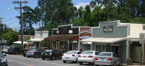
Like all the geographic regions in Maui there are no precisely defined boundaries to Upcountry (more accurately: especially Upcountry!) For example, depending on who you ask, Upcountry can start in, just above, or well above Paia Town. Parts of Paia could be any or all of: “North Shore”, “Upcountry”, “Central Maui” and even “Road to Hana.” One thing is in definite agreement: Upcountry has no water sports 😉
Upcountry Maui has several thoroughfares, but the Haleakala Highway (Hwy 37), Maui’s biggest highway, will be the entry route into Upcountry Maui for most. Other primary roads are Baldwin Avenue (Hwy 390) which heads from Paia up to Makawao; Makawao Avenue (west Hwy 365), which connects Makawao to the Haleakala Highway; Kaupakalua Road (east Hwy 365) connects Makawao to Haiku and the start of twisty “Road to Hana” section of Hana Highway (mile marker 0 of Hwy 360.)
Upcountry it is especially important to take GPS and online maps (including Google Maps) with a grain of salt. Be aware that there are many private, gated, nonexistent, cane and/or 4WD roads that show on GPS as public roads. Also ignore maps that connect Upcountry to South Maui. No public roads exist to connect these areas.