Rating: 

In a nutshell: Na’ili’ili Haele, for most, will be a nice short hike to two or three waterfalls and pools. The more able hikers will be rewarded with more significant sights.
Minuses: Access is restricted by EMI. Can become dangerous to nearly impossible depending on conditions/how far you go.
Sound-bite: “Is that really a ladder?”
Safety Note
The site is now officially closed. This may be the number one rescue spot on the Road to Hana. It’s been very popular, too popular…there are many places to slip and potentially get injured. There are many sad tales of broken legs, flash floods stranding people on the other side of the stream, and even death.
I’m not trying to scare you – many people have had a blast here – I know I have! BUT – please remember everywhere you go in Maui that all outdoor activities in rugged wilderness can be dangerous. Know your limits, respect nature, and understand going in that there are always risks in places like these.
Note: This hike is on private EMI property. The Maui outdoor enthusiast community clearly acts as if there is an implied easement to use these trails after all the years of hiking here – but you’re advised to get permission from EMI as they have officially stated it is closed and attempt to maintain a fence preventing entry. The EMI page has more info about EMI, instructions for obtaining permission and contact info too.
DETAILS:
THESE DETAILS ARE OLDER AND HAVE NOT BEEN EDITED SINCE THE SITE WAS OFFICIALLY CLOSED:
This is a great place for everyone from the fit novice to the extreme hiker, and everyone in between – you really can make this as much adventure as you wish. There is a bamboo forest to walk through on your way to the stream bed (and beyond if you wish), and a string of waterfalls and pools to access (the quantity you will see depends on how extreme a hiker you are!) The first few waterfalls are typically within easy reach of most folks.
When you first get here it can be tricky to find the waterfalls. So that you don’t wind up wandering aimlessly though bamboo forest trails that lead to nowhere, the number one key to remember is that the waterfalls are all found along the main stream flow (thank you Captain Obvious!)
Start at the road, and look for the openings into the bamboo. You can pick any opening and head downhill – they all lead to the main trail. (Note: if you have parked well past the first group of openings – maybe the first 1/10 mile – you may need to follow the stream right.) The main trail soon heads down a sometimes slippery incline (good news is it is short) – hint: bamboo is extremely strong, and most is exceptionally rooted into the soil, you can hold on to it to anchor yourself on slippery sections.
Next you will come to an EMI Ditch, which you will have to step across. It’s deep, but that makes it look worse than it is. The distance across is actually about the length of a person’s stride, so you’d have to be careless and/or unlucky to actually end up in the ditch.
After you have crossed the ditch, you will be presented with a decision: take the high-road, or the low-road. (Those not bound by metaphor can feel free to take either as they both go to the same place.) You’ll soon be at the main stream bed. Depending on how much rain there has been, this may be a trivial crossing of hopping across large boulders, or you may want a length of bamboo to help you keep your balance and/or survey the depth as you walk across.
Flash Floods
Please be aware of unsafe high water or flash-flooding that can occur in North and East Maui streams. This note is found on many articles, if you have not read the flash flood page, taking a minute to do so could save your life.
Read it now
Once across the stream, remember the of “follow the stream bed.” Don’t be fooled in following what appear to be prominent trails away from the stream, these are false trails, maintained by pigs and the constant foot traffic of lost tourists trying to figure out where the waterfalls are!
As you follow a trail that parallels the stream (headed upstream) you will either discover a giant raging waterfall, on the opposite bank feeding into the Na’ili’ili haele stream, or perhaps you’ll pass it, dry and unnoticed. This huge disparity in description (and why it has been left out of most other guidebooks completely) is because it lies directly on the other end of a reservoir that feeds the main EMI diversion ditch, and except during the wettest times, most (or all) of the water that feeds it has been diverted.
First falls after reservoir falls
Continue upstream for a bit and you will come upon another waterfall, with a pleasant swimming hole. SOme folks will be perfectly content here – in fact the last outing I took with visitors we never made it past!
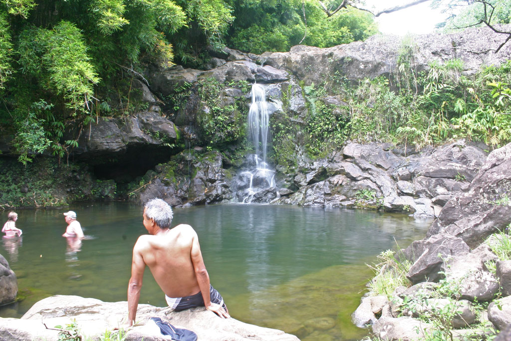
But, if you’re here for adventure, and you are moderately sure-footed, you can continue across the stream, and up a steep, and somewhat slippery hill for the waterfall that our lead image for this article is of. There are some protruding rocks for footing, and bamboo-backup for anchoring yourself should the footing fail. I’ve seen all types of folks get past this one, but it is definitely a place you could take a fairly painful fall if you happened to slip.
As you follow the trail you will come to the falls pictured at the top of the page, which boasts a large, deep pool, and many rock-jumping, and waterfall climbing/sitting options. I rarely take visitors past this one because it’s perfect.
To get to the next and subsequent pool, the hiking gets a bit more extreme, requiring climbing a makeshift wooden ladder (this changes over time.) To get to the fifth waterfall, which is about 35′ and in a particularly dramatic setting, you’re going to have to swim (which shouldn’t be a biggie, since you’re probably wet, muddy and hot by now!)
After number five, the hiking gets much more extreme – however, if you take a look around the Google satellite shots (link below) you’ll observe an outstanding opportunity for the more experienced jungle hiker, with what appear to be truly dramatic waterfalls and gigantic pools further upstream (I have marked the “big” pool described above for scale). I have not yet hiked that far as I’ve got to take out more life insurance before tackling the rockface on #5. Seriously, though – the best way around #5 is *not* the rockface, you can access views of at least one of these larger falls from a hike past the reservoir that feeds waterfall #1.
Key Info:
Mile Marker: #6.7 (Hana Hwy aka Hwy 360)
GPS Coordinates: 20.885207,-156.208211
Facilities: No facilities
Get directions
View Na’ili’ili-Haele Stream & Waterfalls in a larger map
Tracy Lee says:
This was my favorite part of the entire Road to Hana. I would recommend hiring a local guide to take you. There are a web of trails from all the visitors getting lost in the forest. I went with Henry, his IG is @hutchkannon. Found him through Airbnb experiences.
Shannon Mason says:
The final waterfall is the more dangerous one because you have to climb a slippery rock shelf to access. I’d suggest stopping at the third fall especially if you found the ladder intimidating. I do this hike every trip- it’s a highlight. Plan on eating in Pai twin afterward. You won’t be disappointed with this hike!
Heather says:
On Google Maps it says this hike closed – is this true?
Mark says:
Yes, it is now closed though many people have been cutting the fences and are trespassing. I do not advise going to this site any longer.
Shannon wolfe says:
I’ve done this hike many many times- It’s so much bang for a short hike. You will see cars parked at the .5 miles past the 6 mile marker. There’s an fun and not too challenging river crossing maybe 600 yards in- bamboo forest- multiple waterfalls. If you go to the end- you have to swim upstream to reach the final waterfall. Again this isn’t hard my kids first did this hike when they were 5- 8.
Shawn says:
Another fatality here today. Please remain careful.
Vanessa Kirkpatrick says:
My name is Vanessa Kirkpatrick, my son James died November 13, 2018. Any info on that dat that you or any one can give would be appreciated. Email me Kirkpatrickvanessa@yahoo.com
john.russell@ubs.com says:
OK this hike is not for the faint of heart, but it is awesome. I would only do this hike if there was no recent rain or threat of rain. We did this hike over Christmas with a group of 8 adults and about 8 kids as young as 10. We saw so many people with Crocs and flip flops….not a good choice! When we went (no rain) you go down a slippery hill and cross over a stream about 2 feet wide. Then you go through a river, mostly jumping rock to rock and then you pass through a bamboo maze before getting to the first waterfall. Things get a bit sketchy when you get to the ladders and climb up those. Then you walk through a bed of large boulders. After the boulders you need to swim for about 75 feet in cold water to get to the next waterfall. This was the last waterfall we went to and on the way down jumped off many rocks into pools of water and a rope swing. As mentioned, it is important to jump out a few feet from the rocks. I was stupid and did a back flip so I did not clear the rocks by much and my shoes hit some boulders. No one else had a problem at all. Plan on a few hours to complete this hike, For our family it is a must do and we will do it every time we visit Maui as long as the weather cooperates.
Frank says:
This is my absolute favorite Adventure hike on Maui.. I have been so many times this year, I’ve lost count! It has everything thing all in one hike–bamboo, pools, waterfalls, shear cliffs, ladders, boulder hopping, 10ft waterfall climbing all to get to the most beautiful pool and waterfall..
BUT yes, flash flooding is real!! I always check the weather before going in but am always looking for an escape route too..
Enjoy!!
Adrian says:
We took our 19 year old son on this trip today. He was concerned about climbing back down from the next to last waterfall. He though he could safely jump from the top of the fall about 12 feet to the deep pool below. Instead of leaning into the fall then pushing off, he tried to jump. His feet came out from under him and he fell – landing on a rock shelf with about 8 inches of water to slow him down. We had to swim floating him as much as we could and hike over rocks and down ladders and ropes with him having a broken knee cap, fingers, and severely injured elbow. Hospital bill is unkown. This is NOT a place to take your family after the first fall or two. I cannot even begin to stress how slippery and dangerous the trip is to upper falls. If you get to a point that you are using an old muddy rope or a broken down wooden ladder, TURN AROUND. People have been killed and seriously injured here. The only way out if you are seriously hurt is a helicopter ride.
Katie says:
You let him try to jump that?!
Linda says:
He was 19 at the time. Let?
joe says:
Lots of people have been rescued from here in the past week due to being uneducated on the dangers of this hike. Don’t be one of those people and do your research.
Mark says:
Yes, the past two weeks were under continual flash flood advisory and warnings because of two passing tropical storms. If there is any threat of significant rain, going here is a bad idea.
Jeff Steffens says:
Great write up. Didn’t find this until after doing it but very detailed and great advice for people who don’t know what they are getting into. a lot of water going into the stream. Flash flooding is very possible at all times.
Melissa says:
Thanks for the info – I love sharing insights on Maui with my customers before they head to the island
Cri says:
I’m trying to figure out where do i park? And am i suppose to jump the fence if I have a permit?
Bri says:
I love this hike. I live on Maui, and have done this hike several times. As with most surrounding areas, if it is raining or has rained recently, I would avoid this area all together. Just use common sense, check the weather for the day, and you should be fine. There is a lot less people here than in other spots on the road to Hana, which is a breath of fresh air.
Randy says:
My kids and I went a day after a heavy rain and it was raining as we started. No problems other than the water was quite muddy. We had an awesome hike and it was one of the highlights of our time in Maui. So not sure how to tell when to stay out of there.
Both times we were there we met numerous other hikers. I think the area is relatively popular and gets a lot of visitors.
Heath says:
I wish I would’ve read this before I did the hike by myself. I went all the way back and climbed the falls to the big waterfall. Took it in for a while then headed back. Swam back and realized that a flash flood had just came through. I had to wait 8 hours to be rescued by helicopter. Talking to locals they said to make sure to check with the locals before attempting to go to far. Take this advise please my trip could’ve been a lot worse.
Mark says:
Wow Tim – thanks for sharing that. Jumping into the water at that level was dangerous – I’m glad it turned out OK for you. I’d suggest that no one reading this ever try and enter the streams when they flood. .
Believe it or not, flash floods most frequently do come from rain upstream. The mountain is 10,000′ high and these falls are at the bottom of a huge watershed encompassing countless square miles .
The effect is so dramatic, however, because the damming diverts up to a certain capacity above normal flow levels and then the rest spills over the top – in other words, the only reason this is a “lazy river” most of the time is that at typical stream flows the streams are usually sucked dry at the lowest diversion point, and then the only water you usually see is coming up from springs beneath the subsequent pools between you and the diversions.
Once the diversion reaches capacity, an almost immediate addition of water is restored to the upstream flow, and it is a significant change almost immediately downstream.
While not a daily occurrence, flash floods can happen at any time, and I always pay close attention to the water level during any stream hike – glad you’re here to tell us your story!
PS – For folks that are not confident in their ability to be safe, there is an awesome guide named Alicia (search for Awapuhi Adventures here) – Alicia is very knowledgeable and experienced and can take folks to enjoy places like these safely.
Tim Potter says:
Take the warning about flash-flooding in this area very seriously. My girlfriend and I, along with another hiker, were trapped at the base of the fifth waterfall (the one you swim to) when the lazy creek turned into a raging river within a few minutes. The area is like a bowl with steep sides all around and it can get chilly in this area from the mist off of the 35′ falls. I suspect EMI opened a flood gate because the water level changed so rapidly that it could not be due to natural causes like rain.
The problem is that a good portion of the hike back relies on using the boulders in the creek as a trail, which is not possible once the water level rises. It took us 4 hours of strenuous crawling through the rain-forest & mangrove thicket to get out. Not to mention we had to jump off the 4th waterfall (about 8-10′ drop) into the pool without knowing the depth or being able to see into the muddy water. Luckily it was deep enough, but was very hard to fight the current once in the pool.
Our biggest fear was if we had to cross the creek once we made our way through the thicket because you end up on the opposite side of the creek from where your car is when you swim to the fifth falls. Fortunately, you do not have cross the creek on the way out if the water level is too high. About a 1/2 mile below where you initially crossed the creek on the way up to the falls is a bridge. There is a path through the bamboo to the bridge. Put simply, if the water level is too high to easily wade across the creek, don’t risk it and walk down to the bridge!