The stream is a string of pools and waterfalls
Rating: 
In a nutshell: Pipiwai Trail is a treasure of the National Park System that passes through diverse scenery and culminates at the base of an absolutely spectacular waterfall.
Minuses: You’ll be sharing the trail with lots of other folks.
Sound-bite: [insert hollow percussive sounds of bamboo striking one another]
DETAILS:
Taking into account the easy accessibility, the Pipiwai Trail offers, hands-down, the all-around best of East Maui’s most dramatic stream and waterfall hikes.
This idyllic 1.8 mile trail unfolds alongside a string of (many more than seven) pools and waterfalls framed by the lush green diversity of the lush tropical rainforest. The dramatic diversity then suddenly morphs into the zen-oneness of an immense bamboo forest. Once released from the bamboo, you’re dropped at the very base of a towering sheer-cliff waterfall worthy of a slow-motion Imax fly-by.
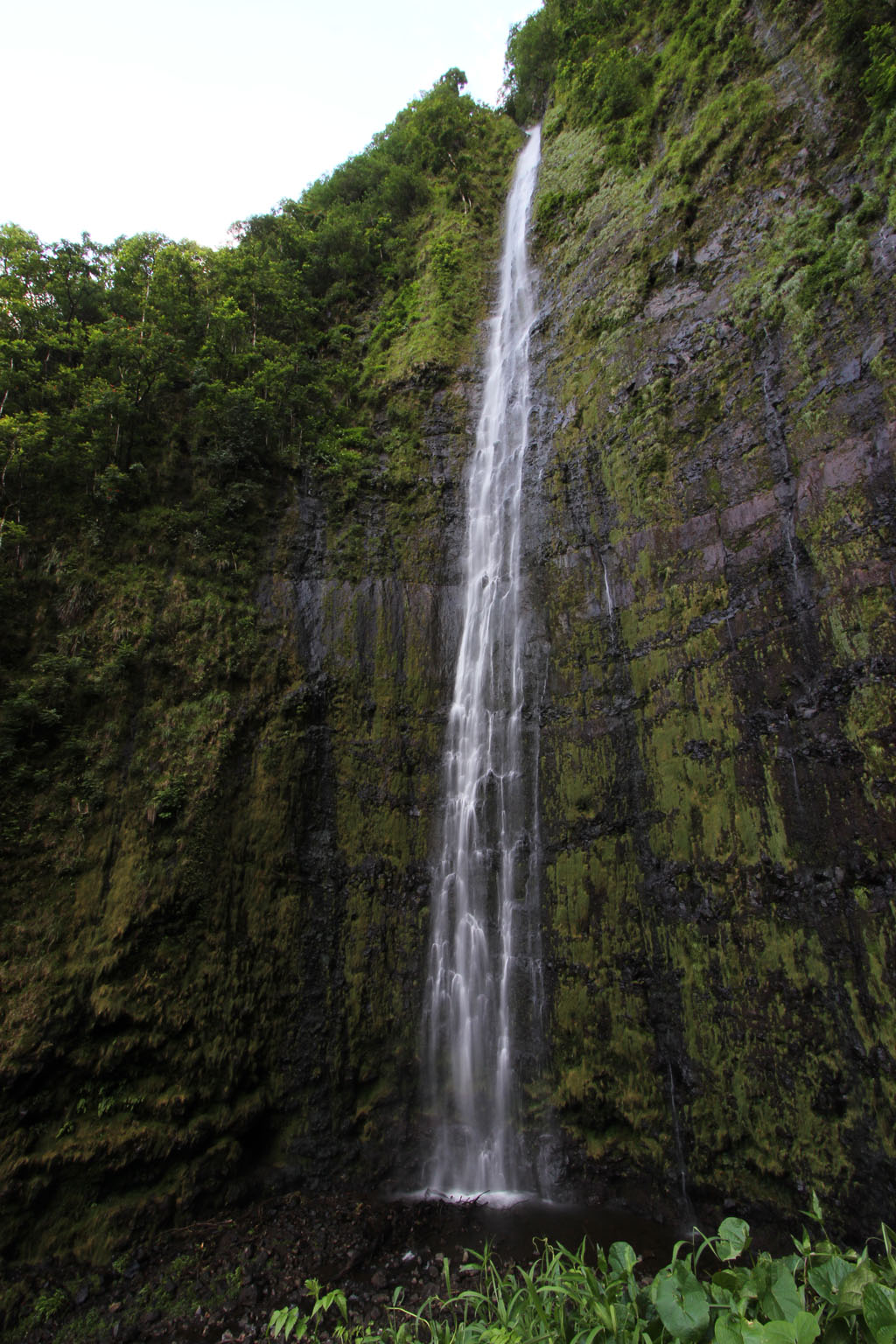
The prize: 400′ tall Waimoku Falls.
The only thing missing from this hike is solitude; because of the easy National Park access, and the half-million visitors per-year to the much more famous pools below, you definitely won’t have this one all to yourself.
The trail is safe, well maintained, and the steeper grade during the first half mile or so is really the only part that is less than easy if you’ve not been off the couch in a while. The NPS has even built a boardwalk to span the muddy sections and have been adding more stone steps in the steeper grade areas in the past couple years – oooh the luxury!
The trail is just mauka the Hana Hwy at Haleakala National Park Kipahulu (Seven Sacred Pools.) and you should give yourself at least a couple hours if you plan to enjoy yourself, add another hour if you stop a lot and/or aren’t a regular walker/hiker.

This NPS Map more accurately shows the trail and streams. (click to open full HNP map from nps.gov in new window)
The trail begins just across the road from the parking lot, and you don’t have to walk very far (just over a half mile) before you come to the first set of large and impressive waterfalls: the Falls at Makahiku. These mighty thundering falls will probably be more than enough waterfall for most. Plunging almost 200′ over a verdant cliff covered with bamboo, prehistoric-looking ferns and Tarzan-worthy jungle vines melting into the postcard-perfect Hawaiian rainforest valley below – the scene is breathtaking. If you’re not fit enough to continue another mile (the hike back is all downhill, so we won’t count that!) you’ll probably be satisfied with these falls as your end-point. But if you’re capable, we want you to know better: this is just an appetizer to ready you for the much more impressive journey to come.
Tip: Take all warning signs seriously. Flash-flooding, rock falls and cliff/bridge jumping have taken several lives, and many natural dangers occur suddenly without warning.
Side Trip: “Infinity Pool”
As you continue, you’ll notice a side path with signs and a recently erected fence barring you from heading in that direction. The National Park Service has blocked this path as yet another casualty of a popular guidebook that doesn’t properly educate visitors as to the dangers in the places it sends them.
This is the absolutely stunning precipice of Makahiku waterfall, a sheer lava-rock cliff face that drops almost 200′ into the valley below. Yes, it is an absolutely gorgeous spot – but certainly not a safe place for every tourist regardless of age and physical condition.
If you want to go here now, you’re going to have to squeeze under or around the fence wherever other trespassers before you have bent it back. Keep in mind that your doing so is against the National Park Service’s prohibition – which could potentially carry a court date and quite significant fines. That said, being cited and fined are unlikely, but you’d certainly better be sure that you fully understand your abilities, the physical risks and the current conditions.
During normal conditions, the water flows over only the far side; the near side of this pool has taller, thick rock lip that will keep anyone with sense enough to stay on the pool-side from a one-way date with gravity. From inside the pool you will observe why the guidebook name makes sense – views from the pool emulate that of a resort-style Infinity pool and are jaw-dropping (to say the least) as the deep blue of the ocean appears to meet the edge of the pool.
Once out of the pool, if you’re an off-trail kind of hiker who hasn’t had enough off-trail, you can continue your side-trip upstream along the streambed (be ready to do some swimming and climbing) and check out some more worthy pools and waterfalls.

Mossy rough-hewn stone block steps evoke scenes out of "The Land of the Lost"
Back On The Trail
Back on the Pipiwai Trail, you’ll pass though a gate and come to another highlight – a gigantic banyan tree – with a footprint the size of a decent-sized house! Over years, a banyan’s aerial prop roots form into new trunks of their own, expanding continually outward. Looking at this tree in front of you, with new trunks sprouted out along the far-reaching branches, ever further from their source, you can see why Hinduism considers the banyan the symbol of eternal life. If you’re a tree climber (or you have some in-tow like I usually do) you’ll be spending more than a couple minutes here.
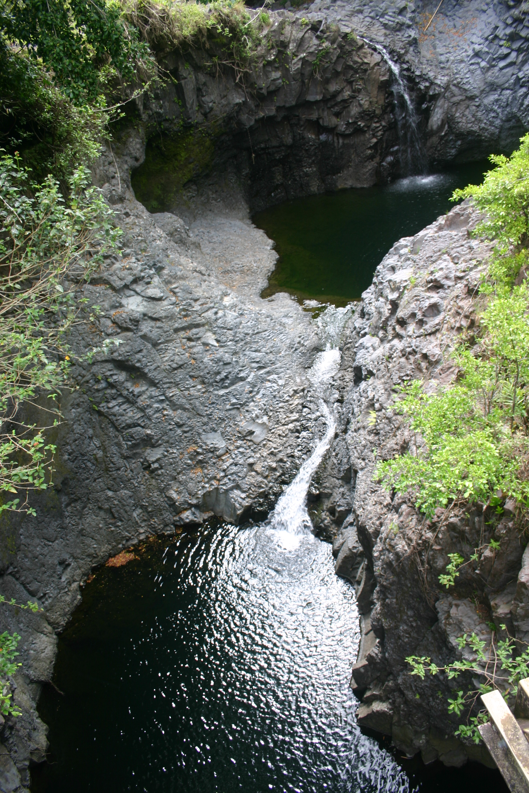
Past the Banyan, another side-trail will present itself (hint: the Park Service has placed a TRAIL arrow here pointing away from it (and toward the main trail.) This side trail soon takes you to a view of cave, pool & waterfall combination that my words (or photography) have not yet been able to do justice. It is definitely a value at the price of a few extra steps.
Continuing along the trail you’ll notice the scenery changing to bamboo. It is a pretty quick change, starting around the time you cross two bridges. Believe it or not, the same nuts brave folks you saw jumping from the bridge at the highway sometimes come up here to get their adrenaline fix. There are only a few choice people I’d advise to attempt jumping here (and it isn’t because they’re skilled jumpers!)
The bamboo will become thicker, and the ambiance and hollow percussive sounds of bamboo striking one another, will begin to transport you to an Asian nether-world. (This is also where the boardwalk comes in and save you from having your shoes sucked off by thick mud.) Various implementations of stone steps, all appearing to date from different periods in ancient pre-history, augment the scene to where running across some Sleestacks hunting dinosaur eggs wouldn’t look out of place in the least.
As the trail continues winding, if you pay careful attention the bamboo will begin to thin and trees will start coming back. It is right at this point that a grove of mountain apple trees can be found (if you know what you’re looking for.) If you’re lucky enough to be here in summer, you’re in for a refreshing treat. Mountain apples are oddly attached to the trees on which they grow. Instead of being on a stem that terminates from a minor branch, like most fruit, mountain apples grow on a small stem directly out of the main branches (and even the trunk) of the `ohi`a `ai tree. (Yeah, you can call it a mountain apple tree!) It definitely looks Dr. Seus-ish to the uninitiated.
Just so you know what to look for – they don’t call ’em mountain apples for nothing – they’re (mostly) red and are shaped like a cross between an apple and a pear. Riper (to the point where the skin begins to crack and become damaged) is better. (more info: Canoe Plants of Ancient Hawaii)
Just a bit further and some rock-hopping over a usually tame stream, and this scenery-packed hike culminates at the base of sheer 400′ cliffs, with spectacular Waimoku Falls quite literally falling to Earth right in front of you. In fact, when you’ve reached the end, you’re smack at the base of the falls, and can walk right up and stand under them. This author (and a Park Service sign a safe distance from the falls) suggest you seriously consider how all the countless boulders you’re standing in front of got there. That said, there is nothing other than your sensibility to enforce keeping your distance, and you’ll certainly observe plenty of people ignoring the sign.
Even at a safe distance you’ll be cooled and refreshed by the mist and wind created by the falling water. Once you’ve cooled down and are ready to continue, you reverse the path from where you came. Easier (downhill) but just as rewarding with a new angle from which to view the scenery.
Key Info: (for trailhead @ HNP Kipahulu.)
Mile Marker: #42 (Hana Hwy aka Hwy 31 – *After Hana markers go back down)
GPS Coordinates: 20.661458,-156.045299
Facilities: National Park Rangers, Information Facility, Camping (no permit req’d), grills, picnic tables and toilets. (No potable water.)
Phone: 808-572-4400
Fee: $15 – NPS Info: https://www.nps.gov/hale/planyourvisit/kipahulu.htm
Get directions
View Pipiwai Trail & Waimoku Falls in a larger map
Steve says:
I would like to take my 87 year old mother for a little walk on this trail. Are there benches anywhere?
Mark says:
There are no benches. This is likely not a good hike for the vast majority of octogenarians as it has a steep incline (especially at the start) and also has challenging footing for most older people. That said, I hope to be able to do it in my 80’s and I know a few very fit 80-year old people that can still do these sorts of things!
Alex says:
My husband and I did this hike today and it was awesome! We live in south Kihei and took the back road to Hana (highly recommend if you are able to). We left around 7:30, got gas at Costco, and arrived at the Haleakala National Park in Hana around 10:30 (we stopped to take some photos along the way since this was the first time we did this road). The trail can be slippery at certain areas due to the on and off rain, so make sure you bring proper hiking shoes, or shoes that have some decent traction. There are a few points where you can catch your breath, drink some water, eat some snacks, etc. It took us about an hour to get to the falls with stops to read some signs and take pictures. Overall, it took about 2 hours in total for us from start to finish, did the short .5 mile loop to check out the 7 sacred pools, and we got back to Kihei around 4:00. Highly recommend this hike if you have the time!!
Cecilia says:
Alex,
we’re planning to visit the park during Thanksgiving week but with COVID19 restriction, not sure it’s worth the drive since some of the area will be closed especially the 7 scared pools. I saw that your post was just in August 2020 and wondering if they have the 7 scared pools open at the time.
Cecilia
Mark says:
The pools are closed often and without much notice; Your best bet is to visit the Haleakala National Park website the day prior to your visit for updated closure information. Aloha!
Dave says:
The “opposite” road to Hana ( going counter clockwise) is not for the feint of heart. While the regular road to Hana is crowded, it is scenic and full of interesting things to see. The other side is one lane for miles (with plenty of two way traffic), it is not well maintained and very very bumpy, it is prone to issues with debris in the road and washed out bridges which require a smidge of offroading. Unless you rented a truck or jeep this route is very hard to navigate and a little scary at times. I would recommend most people take the clockwise (north) route to Hana and just don’t stop at too many stops along the way of you plan to visit this trail.
Holly says:
My fiance and I want to hike the Pipiwai Trail on Wed 6/12/19. We are staying at the Grand Wailea resort. What time should we leave our resort to avoid as much traffic/crowds as we can? Is it worth the 2 hour trip out? Thanks for any advice you can give! 🙂
Adam Grigsby says:
I’m in Hana now. If you drive straight to the trail your be missing so much. The traditional road to Hana is amazing and full of eye candy and begs you to stop and explore. From Kihei it took us about seven hours to get to Hana stopping for a hike in the bamboo forest to the first 2 waterfalls and a swim (about 2 hours) and a stop at Twin Falls for another swim (about 1 hour.) Also stopped at an arboretum (about 30 minutes) and a few stops for lunch and smoothies (maybe another 1.5 hours.) We overnighted here so we’d be able to relax and enjoy the trip. It has absolutely been my favorite part of the vacation so far.
holly says:
Hi would i want to plan a separate trip to hike this or can i do it on the same day as my road to Hana drive? Im staying in Lahaina. Thank you
Mark says:
It depends how long you take to drive the rad to Hana. I would just plan to leave Lahaina before sunrise if you can, and take your time enjoying yourselves. If you get to the Pipiwai trail hike too late to do it, I imagine you will have had a very satisfying day and wont be sorry!
Ariel says:
If you plan on taking it all in, it’s just way too much to do in one day. I did the road to Hana two consecutive days, one day break, and one extra day (3 in all the same week).
You could (A) do it tour bus style in your own car, meaning you do the road to Hana, stopping for like 5-10 minutes per location and moving on, then do the big hike at the end to Waimoku Falls and stop to see 7 pools on the way back. (Again, 5 minutes per destination except the last hike).
Or you could make it a 2 day trip if you plan to sleep in some hotel in the road to Hana (I’m not that rich, tyvm. It’s enjoyable either way and you won’t feel regret.
I will warn, the road is windy at some places and not everyone can handle doing this trip more than once. I did because it’s gorgeous and I took my sweet time to bask and absorb it all in. I was in no rush.
Kelsey says:
Do you have any pictures of the cave/pool/waterfall? I hiked this trail back in May 2017, but didn’t know of the side trails at that time! I’m going back this May for my honeymoon and would love to explore the side trails this time!
Erik says:
Pipiwai trail is a great adventure if you are willing to brave the possibilities of slick and muddy trails and mosquitoes. Please do not wear flip-flops. I saw 2 people who were walking gingerly down the trail in bare feet carrying their flip-flops.
The O’heo pools are very close to the visitor center but are still closed to swimming.
Erin says:
What time does the park open to start hiking the Pipiwai Trail? Also, is there an address for the park? Thank you!
Mark says:
The park is open 24-hours. You probably don’t want to hike it in the dark though! There is a google map on this article with the location. I dont beleive the mailing address for the park is at this location. Check the Haleakala National Park web page if you need to mail them something 🙂
Robert Perez says:
Is this still a worthwhile trip and hike? I’ve seen elsewhere were they have closed access to the pools and you can’t get close to the water to see the falls. I’ve also read that the water levels are very low or none existent. What are they like in October?
Mark says:
This is always a worthwhile hike 🙂 The water is definitely not low right now, that is old info and changes with the weather. We have had tons and tons of rain in the past couple months. Best bet is to check the Haleakala National Park website the day prior to your trip for real-time closure info. Even if the pools are closed below, this hike is exceptional.
Larry Sherwood says:
October is GREAT time.
Jesse says:
I am an expereinced hiker and plan to take a 14 month old with me, obviously I would have her in a backpack carrier. Is this hike safe enough to carry a toddler in?
Mark says:
I have taken all four of my children on this hike countless times from the time they were little babies in carriers. That said, an 8-year-old girl was tragically killed on this trail from a falling rock while we were hiking it in 2011. There was nothing different that day than any other day, a rock fell, as they do from time to time, and struck a child. There is nothing specifically of danger to note if you stay on the trail, but things can happen in wilderness. Hope that answers your question!
Chris says:
Mark. We are visiting from Washington in April. My Family and I love rock climbing as well as hiking. I see some guide services offer rapelling. I am wondering if you know of any public access areas that would be available for use if we brought our own equipment. Trying to decide if it’s worth bringing a rope etc or just stick with bouldering. Thank you!
Mark says:
Hi Chis – I don’t know anything about repelling – however I do know that many of our cliffs are quite prone to fracturing and breaking apart, so my advice would be not to try this without a guide who is very familiar with Maui. Have fun!
Angela Simonson says:
How many miles in to the bamboo forest?
Mark says:
It’s roughly a mile or so in.
John Moerk says:
Do the falls by the bridges have names?
misschili says:
I am going next year with a large group of all ages. Is this safe for toddlers and infants of 7 months?
Coconut Condos says:
We packed in our 3-year-old, had a backpack for when he got tired, but he walked a good part of it. Maybe avoid the side trails…
Rosie says:
yes it is safe as long as you have a good hold on them along the trail. Dont let them wander.
Sol says:
Are there dogs allowed
Jen says:
Whats the best route to take to get to trail head from Lahaina?
Mary Anne says:
My husband and I are over 65, fairly active, and would like to hike this trail this February. My only problem is that I have a height problem. Are there any points in the trail that have a narrow point and dangerously close to edges.
Mark says:
There are no height issues on the trail 🙂 Have fun!
Brittany says:
Aloha,
My fiancé and I will be going to Maui this July for our honeymoon and would like to take a tour that includes this trail. I am aware there is a guided tour option, are there any tour companies that have his trail part out their day tour?
Emily says:
Aloha Brittany,
Check out Epic Experience Maui if you would like to consider some private tours!
Mahalo,
Emily
Darren says:
Hello!
I am an active 20 year old male who has an extra day in Maui and read so many wonderful things about this trial. I am not a hiker but I think I should be able to handle this trail. Do you reccommend going alone or paying for a guided tour?
Thanks!
Mark says:
Aloha Darren – I just hiked it yesterday – love this trail, if you are 20 and active, you’re all good 🙂 You don’t need a guide, just give yourself plenty of time to enjoy!
Drew says:
Aloha Mark,
I’ve really enjoyed reading about these wonderful hikes in Maui. Your humor and descriptive writing are perfect! My wife and I will be in Maui Summer 2016 (without the kids!) We were on this – greatest of all islands – for our honeymoon in ’03. We BARELY survived the hike back out of Sliding Sands Trail back then, but discovered our love of hiking together. A few pounds lighter now, we cannot wait to take on the challenge and reward of a few of the hikes in and around Hana. Thanks so much for sharing this info!
Lori says:
It’s a great hike. Easy yet challenging. Bamboo forest is magical. Try to get there by 10 am or earlier for heat comfort. Good for anyone relatively active and healthy. Places of shade and cool breezes. We have done this in Feb 2015 and 2016. If over on West side/Kaanapali – leave at 630 am or 6. Wear comfy sneakers and clothes. You will sweat. Make bee-line for State Park. Past Hana. Stop at Honolulu Coffee in Paia go restroom and breakfast . Stop at Travaasa in Hana for restroom and gift store. Eat at Thai by Pranee in Hana after the hike. On way back. Take your time on way back. Enjoy the Hana drive.
jen says:
Hi Mark,
I would like to hike the bamboo Forrest. When is the best month to hike the trail and what airport is closest? Thank you!
Jen
Mark says:
Aloha Jen – it really is wonderful year-round. Hana airport is the closest, however, if you’re not flying in from another island to stay in Hana specifically, you’ll likely want to drive from where you stay. The drive is an adventure in and of itself! Have fun!
Sam Shannon says:
Hi Jen,
The Hanna airport is the closest, but getting a commercial flight there is probably going to be difficult.
My favorite time to hike the bamboo forest is in February. It’s warm, yet not hot and there’s always a chance for a light cool mist. Love hiking the bamboo in a fine mist. It’s beautiful.
That being said, you will probably need to fly into the Kahului Airport (OGG) and either rent a car or hitch-hike to the trail head. The problem with hitch-hiking is, although everyone wants to drive to Hana, most people will not drive the Southern route where streams over the road and often wash them out. Many rental car companies use to prohibit traveling on that road. If you can find someone taking the southern route, you’ve got it made. Otherwise, you can take the Northern route and simply get out when most people turn around. It will probably be easier to find someone heading your direction from Hana anyway.
I hope this helps
maryann says:
can we swim in the pools at the base of the falls?
Mark says:
The pool at the base is shallow – people wade in and stand under the falls, though the park service now has a highly ignored sign in the middle of the trail when you approach stating not to pass the sign.
Richard says:
Call ahead. We went in late Sept. There were Heaney rains.
The pools were closed. Looked like Rapids . The false looked like Niagara.
It was awesome but it did add to the danger
Tom Lacy says:
Is getting to the pipiwai trial from the west doable ?
iris says:
aloha! im planning a visit to maui in october. I was wondering how difficult it is to cross the stream? We are going with a few older companions who might not be able to hop across rocks and do not know how to swim. Is it shallow enough to walk in the stream to get to the waterfall? This site has been very helpful. Thank yoU!
Mark says:
Aloha Iris – It is shallow enough to cross without swimming, however the stream bed is boulders and rocks, is quite slippery and footing may be difficult for your older companions depending on their agility.
wayne tryba says:
I am going to Maui the third and forth week of march 2015. I want to hike the trail but my wife is not capable of this type of hike. How much time will it take me to hike up to the 400 foot or last waterfall on the trail. I would like to know the round trip time with a few stops along the way.
Alexandre says:
The trail is fantastic.
Me and my girlfriend started in mid-afternoon and really enjoyed it. The first part was under the heat and sun, but when you get deeper into the forest (and especially bamboo forests), then it’s more comfortable.
Some people decide to swim on their way, either in rivers or at the very end under the fall.
It takes about 1h00-1h30 on the way up.
Then 45 mins way back.
Jane says:
My husband has a bad knee (it hurts to walk), but I can get him to walk around the neighborhood. Is this a steep incline, putting more pressure on his knee?
Bright says:
How much time should we allocate to do this hike? We’re a couple who are fit for someone who doesn’t go to the gym…
Mark says:
A coupel of hours for sightseeing 🙂
Doug says:
Nov. 2 – 9- 2014….knock me over w/ a feather…This hike is a Fait Accompli…what else should we put on the ‘Must Hit’ list…?
Megan says:
Aloha Mark,
As it is now rainy season here in Maui, and the trail crosses a stream it sounds like, does the water level ever get too dangerous and high to pass during April/May?
Thanks Megan
Mark says:
Aloha Megan – its typically not deep, but, as always, use your judgement, and if in any doubt, ask/see if others are having any difficulty crossing. Have a blast!
mamalu says:
Aloha… we will be in Maui next Christmas..we would like to take the Pipiwai trail. We will be staying in Kihei. Is it advisable to take the road back thru Kahului and down as opposed to taking the rough road outlined on the western side of the island that goes thru Keokea.
Mark says:
Aloha Mamalu – check out this post: http://mauiguidebook.com/adventures/itinerary-shelbys-kipahulu-day/
Joanne says:
Aloha, would the trail through the bamboo forest be suitable for a 5 and 3 year old. Would love to do this but if it isn’t suitable for young children, we wait on it. Thanks
Mark says:
Aloha Joanne – it depends how used to hiking or fit the children are. I have hiked this trail with children dozens of times. It is a well maintained trail with two shallow stream crossings at the very end (after the bamboo.) If they can walk 3-4 miles then they should be fine doing the whole thing – there is a lot of interesting scenery (even for kids!) and a great banyan tree for climbing right on the trail about 1/3 of the way up. There is an incline, but it gets less once you pass the banyan (and normally doesn’t phase active kids…out of shape adults are another story 🙂 )
Holly says:
Really want to do this hike but concerned about my level of fitness for incline hiking. Not worried about the distance. Can you tell me how far the steepest elevation change is and what degree of incline that part of the trail would be? Weird question, I know.
Mark says:
Aloha Holly – not sure of the specs – how fit are you? Can you give me an idea of what kind of physical activities give you difficulty?
Donna Putt says:
What are the hours of the Pipiwai trail?
Mark says:
Aloha Donna – the trail does not close, though I would not suggest doing it in the dark!