Rating: 

In a nutshell: An easy 30-minute hike can turn into a spectacular multi-hour moderately easy-going hiking adventure. Graded un-paved access road passes for miles through an undeveloped Eden of Maui rainforest and watershed.
Minuses: Access may require permission from EMI. On weekends you might encounter boar hunters and their pit bulls.
Sound-bite: “Yesterday I found the best hike on Maui that I’ve done.”
DETAILS:
You can make this hike what you want of it. You can dip in a cool, fresh pool complete with dramatic waterfall in as little as a half an hour round-trip. Or take the better part of a day to hike into largely untouched and spectacular rainforest.
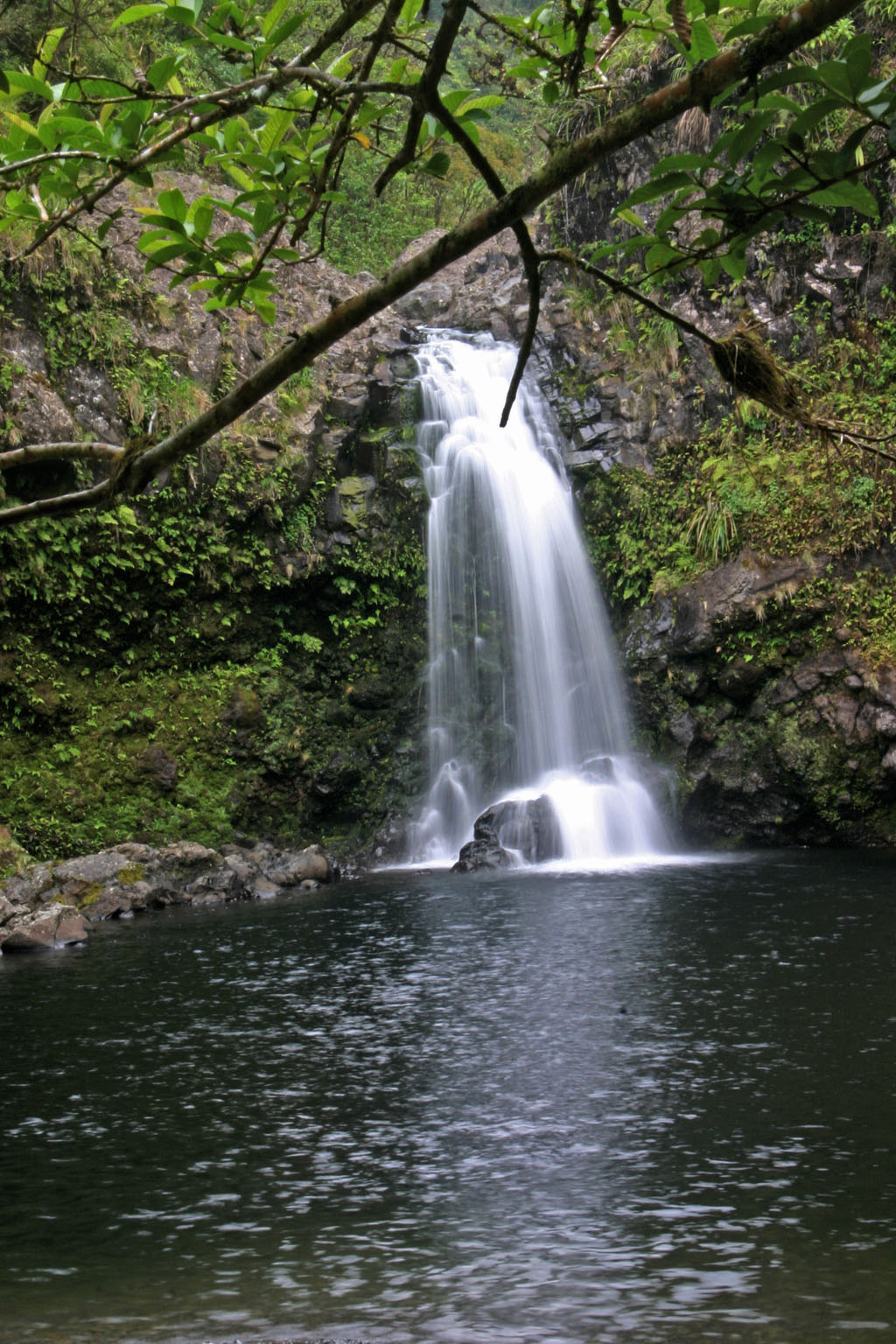
Plenty of places to cool off!
This location is little more than a side-note in guidebooks – in fact, to my knowledge only the first set of falls have been detailed in print, and as a result virtually all turn back at that point.
If you continue, the Wailua and Ke’anae valleys slowly unfurl an endlessly changing panorama so spectacular, it almost feels as if you’ve stepped into a dream. Steep valley walls, countless cascading waterfalls, tropical flowers and plants in every hue of the rainbow are painted onto scenic vistas that are so vast, and so awe-inspiringly beautiful, they’re sure to invoke a special feeling inside that can only be accurately described by invoking Hawaiian: This is Aloha O Ka ‘Aina.
If you’re a nature lover, without a doubt you should be staying somewhere close to the Road to Hana for at least a few days. So if you have made the time, devote at least a couple of hours here. When I visited this Eden for the first time, I was transported to a place where there was no where else in the world
I wanted to be. The hike, as it revealed itself was narcotic. I did, in fact, have somewhere else to be, but I kept finding my pulse quickening, and my desire to just go a bit further irresistible.
Important Notes: Please be aware of unsafe high water or flash-flooding that commonly occur in East Maui streams. Portions of this hike are on EMI easements leased from the government. Please see the EMI page for more information.
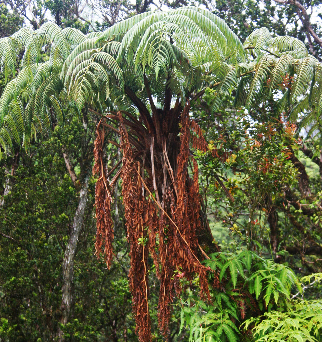
Endemic Male Tree Ferns abound.
[The following is excerpted from a 2001 newsgroup post by hiker Eric Stelene]
Yesterday I found the best hike on Maui that I’ve done so far and I’ve named it Wailua-Keanae. This 12 mile round-trip hike on easy dirt roads takes you past no fewer than 20 waterfalls as it parallels the Hana Highway then descends gradually down the sheer pali into Keanae Valley. A short walk along the broad valley floor then leads to a stunning climb straight up the back of an amphitheater on a long-forgotten trail to a notch in the pali with thundering waterfalls. You’ll also get an up-close view of the East Maui irrigation system that takes water to central and upcountry Maui. All you’ll need is a wavier from East Maui Irrigation to access the land (not that I had one or anything)
The trail for this hike is actually a century-old 4WD road (Wailua Iki Rd.), which is still used by EMI and (more regularly) by wild boar hunters. (Even if you’re a PETA member, understand that hunting wild boar is a greater good for the environment here. They are an invasive introduced species, and are responsible for significant destruction to the native ecosystem.)
Follow the trail uphill until you see another well defined path/road on the left. Keep right at this juncture. You will soon start downhill and be treated to a scenic view of two large pools, and at least one set of roaring falls just prior to where the water is diverted. Compare these falls with the almost dry streambed just after the diversion. Now you know why environmentalists and Native Hawaiians in the Taro fields of Keanae and Wailua (downstream) have been fighting long and hard to have some of the East Maui watershed flow restored to the streams.
As you continue downhill toward this first diversion, you will come to a concrete bridge, and a closer view of interesting water diversion structures and ditch system. This pool is cool and refreshing, and there are several places to jump should you be so inclined. (It should go without saying, but I’ll repeat my mantra anyway: always check landing areas before jumping.)
As you continue on the hike, the path will zig and zag at around 1200′ elevation for about three miles. (There are elevation changes, but nothing major.)
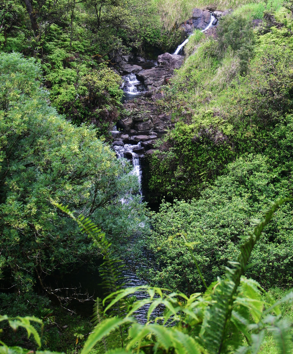
Wailuanui Stream View from EMI Road
After you pass the second bridge, the valley starts to really open up, and you will soon begin to have vantage points of a chain of falls that will make you realize how utterly limited my photographs are at conveying the majesty and awe-inspiring beauty of this valley. Depending on the cloud cover, you will also begin to be able to view Ko’olau Gap and the ridges that form Haleakala Crater.
Throughout this hike you will pass various implementations of water diversion, all feeding the main artery of the EMI ditch system. Much of this construction is very interesting – especially considering it was originally built by hand, without the aid of heavy machinery (as were the road you’re hiking, and the bridges you’re crossing.) Speaking of bridges, by their design, they appear to be constructed by the same folks that made the older Hana Hwy bridges. Most are marked with “A.D. 1923.”
As you continue, you’ll pass many more waterfalls and pools until you reach Waiokamilo Falls, which is raging most of the time. Views from the bridge are stunning and expansive. Ke’anae Peninsula and the deep blue Pacific Ocean beyond, beckoning. Eric Stelene noted that this bridge had the year 1922 on it, and deduced that the road was constructed beginning at the valley floor, and up steep cliffs (rather than down into the valley from above.) I would agree – and, from this perspective, I marvel at the impressive ingenuity, combined with a work ethic of kryptonite that must have gone into accomplishing this engineering feat.
After the 1922 bridge, the incline (which you have been slowly descending) begins to become more significant. Thanks to the increase in grade, you’re soon on the floor of the Wailua Valley. A good place to continue Eric’s perfect description of his hike:
Go around the gate and reach the junction with Piinaau Road. There is something that looks like a headstone here with Chinese writing on it…Turn left onto Piinaau Road and follow it up a short ways. Another road comes in on the left by a concrete bridge. Go left and cross the bridge, you’ll soon see waterfalls hundreds of feet high cascading over the valley walls. Follow this road to the back of a deep amphitheater. The road suddenly ends. Look carefully and you’ll notice a faint path leading up the embankment just before the end of the road. The path widens a bit and starts to switchback up and up. 600 feet straight up the pali. It’s overgrown and very narrow in places. I could just tell that I was the first person to use this trail in a long time. The blanket of leaves on the ground looked undisturbed, so did the thick carpet of moss on the loose rocks. I decided to name this the Lost Pali Trail (LPT). In less than 30 mins I came to the last switch back and a notch in the pali with a powerful waterfall. Above that, two waterfalls tumbled about 200 feet from the plateau above in to a plunge pool which fed the lower waterfall. There were some parts of the irrigation system all the way up here – a small concrete structure and and tunnel leading into the mountain.
For the unobservant hiker, the pool here would be great to jump into after the steep climb. You may notice all the water flows into the pool yet none flows back out. There must be some kinda of tunnel in the pool itself that could suck a swimmer to his death.
I rested here a while, it only took a little over 2 hours to get here. I waived at a tour helicopter flying low overhead. The pilot circled around and came lower apparently to see if I needed to be rescued! I bet he was a little surprised to see someone all the way up here.
I had my rest then headed back down the the LPT and got to the bottom in about 20 minutes. I was soon climbing back out of Keanae Valley and at the Waiokamilo Falls bridge. I took another short rest at the top then was back in the Jeep in less than 5 hours total. Thanks to the easy roads, I was in very good condition considering the distance I traveled and the terrain I crossed.
Now, looking at a terrain map, it would seem one could continue downhill, down Piinaau Rd. to Hana Hwy at Ke’anae – but I’m not actually sure how far that would be, and then you’d have to hitch-hike ~3 miles back to your car as walking on Hana Hwy is not advisable. I’m going to do that in the future and I’ll post my findings.
Key Info:
Mile Marker: #21.2 (Hana Hwy aka Hwy 360)
GPS Coordinates: 20.821843,-156.137974
Facilities: No facilities
Get directions
View Wailua & Ke’anae Valley Hike in a larger map
kuuipo naone says:
hunters are in the area often. for safety reasons people should stay out.
Lisa roberts says:
I am here in Maui and I was wondering if anyone has recently traveled this hike. Does anyone know if this was the hike that David toeller died on December 29, 2001? He was my dad and if possible I wanted to travel that hike with someone that knows the land for safety. It was a 12 mile u hike in the kaenae mountains. If you have any information I would really appreciate it.
Mark says:
Hi Lisa – I did a google search and the only record I could find of your father’s death that indicated the location sayid only “EMI trail in Keanae.” This is indeed the primary EMI road/trail between Wailua and Keanae, as it would have been in 2001. The trail does go the distance, and if you read the hiker’s description quoted, I could imagine that the end portion of this trail is treacherous. I can not help you with a guide, and technically you will be trespassing. It may be worth a stop into the EMI office and talk to them about a waiver under the circumstances. Perhaps they will be able to recommend someone willing to take you.
anonymous says:
Hi Lisa,
The hike you are referring to may be the Honomanu Uka trail that Eric Stelene describes here: http://extremehikinghawaii.blogspot.no/2011/03/honomanu-uka-maui-eric-stelene.html
Notice the second comment: “If you had continued on into Keanae Valley, you would have come to a fence across the jeep trail. The fence was erected after a huge landslide took out a great portion of the switchback trail into Keanae valley. You should not try to cross the landslide. A few years ago a local doctor did and fell to his death.”
Laya akuna says:
Private property. No try
Sal says:
Has anyone done this hike recently? After reading Nick’s comment from September I was wondering if the road is accessible again?
Thanks!
Nick says:
A friend of mine and me attempted on this hike today. We started at the parking at around 1:30 pm. The trail was quite humid and you could see how high the water was last week. After about three miles of hiking my friend told me suddenly: “I guess that’s the end of our hike today!” I was walking behind him and from one moment to the other there appeared a big landslide which took down approximately 60 foot or even more of the old 4WD road after the heavy rains last week.
We were standing in front of this landslide for about 15 minutes, figuring out if we should try to walk over it and continue our hike. But as we couldn’t see how it would be on the other side of the landslide, we decided not to go. It was really too sketchy and we didn’t feel for dying today!
If I could I’d put a picture of the landslide with this comment…
I hope to do the rest of the hike one day as it seemed to be a really nice one so far…
Andrew says:
Update July 2016
We walked up the Pi’ina’au Road to the Devil’s Pot. Easy walk, around 3 miles, gentle gradient up. Fine swimming hole about half way, hard to see from the track.
At the top, the trail that is labeled the LPT in the above article has been recently maintained. I guess this was related to the opening of the sluice at the top to feed water back into the Pi’ina’au stream following arguments about water rights. Thus it may not stay maintained for long.
Andrew
Andrew K Smith says:
I completed the entire trail to the letter on MLK Day, reaching the three-tiered falls up in the pali after 3.5 hours. It was hardcore. I don’t recommend it to anyone who lacks experience hiking in Hawaii. The directions above are excellent, but a GPS app with USGS topo will lend confidence to the hike. Leave Hana Highway before noon and check the NOAA weather forecast to ensure that dry conditions will prevail over Hana and Haleakala on the day of the hike. There are no trail markings of any kind other than three blue barrels on the final switchback. The palii falls are surreal, and make all the mud, overgrowth, and uncertainty well worth the effort and risk.
Trevi Moonbeam says:
Andrew, thanks for your comment. I and a few friends attempted this hike in Oct 2012, but turned around before we made it to Waiokamilo Falls because of all the overgrowth, mud and uncertainty. I am considering going back after reading your comment.
By the way, was there water on Waiokamilo Falls? It looked bone dry when we went. Not sure if it was simply because of the season or if the flow has been diverted for irrigation.
Sue says:
I’ve done this one a few times, but never get past the 1922 bridge. I’ve been up Pi’ina’au Road a couple of times, as well. Not having any idea that it connected to what I always called the Wailua Iki Trail. From Pi’ian’au, I’ve gotten to the faint trail, but didn’t quite make it to the end that is described here, but have seen from afar the waterfalls mentioned. The Wailua Iki Trail can be really easy or really hard and I’ve had it both ways and in between, too. We’ve turned around when it was too slick and been disappointed when the giant falls at the bridge was bone dry. It’s beautiful no matter what, but use sense!!
Scott Innes says:
Thank you for a well written description with appropriate warnings and recommendations. We took this hike yesterday and followed the trail almost to Waiokamilo Falls. About a mile before the falls there was a huge Eucalyptus tree that recently fell across the road completely blocking it from any possible vehicular traffic. We climbed over and continued to Waiokamilo however farther up the trail the road was so unmaintained with thick brush and overgrowth that we did not continue and started back before making it to the bridge over the Falls. it was well worth the adventure even though we didn’t get to see the view from the bridge. I don’t know if our GPS was off but the coordinates you list here took us to a bridge on Hana Highway about a 1/2 mile before the gated entrance to Wailua Ike Road, which is where we needed to be to start the trail. We found our way after driving a little further.
Walker says:
A lot of good points, and the contact info and waiver suggestions for EMI are great suggestions for everyone venturing on EMI leased or owned land. Many would argue (I believe correctly) that EMI does not have the right to restrict access to State and County owned lands where it only leases the public water rights. Practically the entire East Maui watershed would become EMI property – which it most definitely is not.
Thanks for taking the time to share this info because one of the moist important purposes I’m trying to accomplish with mauiguidebook.com are to educate on the safety, cultural, environmental, and local respect issues that Maui Revealed and other sources carelessly omit – and to give everyone a voice to be herd at the same volume. I’m really counting on folks like you sharing their understanding.
There are also several places linked form this page that all readers should read – your comment touches on them also (flash floods, ditch system, etc) and has important information to take into consideration.
If possible, I’d really like you to take this specific hike and comment back here – I don’t believe this hike holds any dangers above and beyond what visitors could expect at any waterfall or stream until several miles in. At this point I would assume we only have experienced hikers making it that far, and the dangers are clear and not hidden (ie. climbing up the pali, etc.)
Locals Perspective says:
This seems to be one of those examples of tantalizing hidden mysteries of Maui with compelling descriptions of stunning vistas, etc. … but not nearly enough emphasis on full disclosure, safety, Kapu or trespassing & privacy issues.
Depending on the time of the year and recent rainfall, several areas mentioned along this hike could be very dangerous. Flash floods can occur with no warning from rain clouds you can’t see, caught on the upper reaches of Haleakala.
EMI does have a system in place to grant official permission to hike in certain areas of their leased land, but that system is set up to protect the company from liability – not to protect you if you get injured or killed. The Sierra Club lists the following as required procedure: EMI will allow some to hike across certain sections of the leased land so long as each hiker has a waiver, carrying it with them during the hike. An EMI WAIVER IS ABSOLUTELY REQUIRED. Call in your waiver request to Jackie at 579-9516 well in advance [5 days prior] and MAKE an appointment – at a time that is convenient for her – then go by the office to sign the waiver and get your copy. The Pa’ia office is at 497 Baldwin Avenue.
There are Sierra Club hike leaders who can serve as safety and informed local access guides. Call them to see if they cover this area, or have recommendations about it – 808-573-4147. Connecting with the Sierra Club may be the best, safest and most respectful way to handle hikes through areas such as this.
And absolutely do not wander into or too near the EMI ditches, culverts, tunnels, pipes or flumes – most of which were constructed between 1876 and 1923. Keep yourself and your friends and family safe. No matter what some residents might choose, i.e., ignoring No Trespassing signs, either in protest against EMI and the ongoing disputes and legal battles, or out of ignorance, or simply for their own convenience, your safety is paramount.