Rating: 


In a nutshell: Rugged shoreline, scenic vistas, and cliff-edge driving you’ll never forget.
Minuses: If you’re not a confident driver parts of this drive could be your worst nightmare.
Sound-bite: “what do you mean back up!?!“
Most visitors will travel in and out of West Maui along its West and South shores through Maalaea. This is definitely the commuter route, as the route along West Maui’s northern side is precarious and slow going. For those seeking adventure, this open-vista driving tour is a must-do.
The north shore of West Maui has been called “West Maui’s Road to Hana” – but that really is a generalization best left to those who just don’t get it. (If we’re going for broad generalizations here, the Back Side of Haleakala is the closest you’ll get to this.) If you have an adventuresome spirit, you owe it to yourself to drive both of these roads during your visit. By the same token, if winding narrow roads at the edges of cliffs make you nervous, or if you already did the Road to Hana and can’t figure out what all the fuss was about, you may want to give this journey a second-thought. (For the record, if you must pick one, it is no contest: pick the Road to Hana.)
Does driving here void your rental car contract, and can the car even make it?
First, lets dispel the pure myth that it is difficult for regular cars to make it around this side of the island. It’s not. Except during extreme weather events, this entire road is navigable by pretty much any vehicle (though smaller is better!)
There is a portion of the road that is perched precariously on the cliff’s-edge, and if you get a flat out here, you may revisit the experience in nightmares for years after (ask me how I know!)
The second most often repeated myth, that driving on this side “voids your rental car contract” is actually based on a grossly exaggerated smidgen of truth. I called five rental car companies and all five confirmed the same thing: if you get in trouble out here, you’re on your own to get yourself out of it.
So caveat emptor: if you get a flat perched on the edge of a cliff you’ll likely be paying for the tow truck (and dealing with a lot of frustrated drivers!)
Read more
For all but the most confident drivers, going clockwise is recommended as it puts you on the body-shop side of a miscalculation. If you do decide to go against this advice, be certain the person riding shotgun is equally as confident in your driving abilities.
Past Kapalua
As you leave Lahaina and Ka’anapali you start to see something you haven’t seen in a while: clouds! That is because you’re traveling from the dry leeward side of West Maui into the wet windward side. Clouds usually build as the day progresses.
After you’ve put Kapalua behind you, you’ll come to Honolua Bay. We’ve done a separate article on this beach and bay, so I’ll just say it is a protected cove with rocky beach that is usually a spectacular place to snorkel, dive or surf. For more info see the Honolua Bay article.
(33.3 mm) Lipoa Point
GPS Coordinates: 21.019269, -156.639426
A great vantage point for Honolua Bay, with dirt road and trail access to the shoreline for the explorer. There are many rough paths leading down to the shoreline tidepools, caves, surfing and snorkeling access. 106 acres of the point’s headlands are in conservation. This area was an ancient Hawaiian fishing ground and the headlands contain many archeological sites that have not yet been preserved, marked or maintained. Please be very respectful of the fact that this is an important cultural area deserving of respect – if you see rocks piled as a wall or foundation, look and imagine what they once were – but do not disturb them. Most of the trails down to the shoreline are rough (and some are downright dangerous) – so use your head before you decide to adventure down any of these.
(34.6 mm) Punalau Beach
GPS Coordinates: 21.022176,-156.625997
Punalau Beach is a rugged sand beach, the last sandy beach for quite a while, in fact. This isn’t the best place to lay out or go for a swim, but it is a spectacular place to take a quiet and secluded walk. When the surf is up in the winter months it may become crowded as surfers use this beach to access the popular “Windmills” surf break offshore.
Look for a turnout with some parking. Be sure not to block the 4WD road, and don’t drive down it even if you have 4WD and the gate is open.
(36 mm) Honokohau Bay
GPS Coordinates: 21.022161,-156.60992
Honokohau Bay has a rocky beach and is used for kayak launching and is another surf spot during winter months. The small village of Honokohau is also just uphill, but is not a place for tourism. Please respect their privacy and right to quiet country life by avoiding a spontaneous drive up their dead-end country road.
(38-38.5 mm) Nakalele Point
GPS Coordinates (light beacon): 21.028951,-156.590506
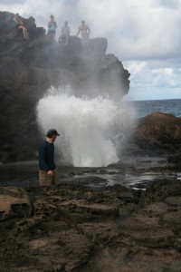
Most frequently visitors come here to see the blowhole (below.) There is also a short hike past tidepools and interesting rock formations caused by the effect of countless years of the corrosive effects of the blowhole’s salt spray. Part of this area is called the fantastic name of “acid war zone” by more than one popular guidebook. For those interested in geology, it is definitely a sight you won’t want to miss and is all covered in detail in the dedicated article on the blowhole.
(38.5 mm) Nakalele Blowhole
GPS Coordinates: 21.027013,-156.588559
The prime attraction of the Nakalele Point is the blowhole. A blowhole’s effect is much like that of a geyser, a hole in the ground with a jet of water shooting periodically into the air. This blowhole has a manhole sized opening and can be very impressive during high tide and high surf. (tide forecast) Some jets can approach 50+ feet and literally shake the ground beneath your feet. Nakalele Blowhole Page
(16 mm) Olivine Pools
GPS Coordinates: 21.009933,-156.556061
I covered the Olivine Pools in its own article since it is such a popular place. They are a handful of nice tidepools at the end of rugged lava jutting into the ocean. Pretty spectacular when you have them to yourself, these days they’re sometimes pretty crowded. Olivine Pools Page
(14.6 mm) Kahakuloa
GPS Coordinates: 20.997022,-156.550991
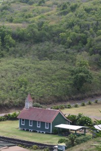
Kahakuloa is a small isolated village nestled along the shoreline. Called the most isolated village on Maui, most of the folks who live here work here, too. The old and simple missionary founded church (1892) is the subject of many paintings and photographs because it is idyllically situated against both mountain and ocean backdrops. Taro lo'i and modest homes dot the tiny village inside this scenic cove.
There are a couple of roadside stands here – one inside the village, and one on the main road. Both have plenty of Aloha and great treats and fruits and are definitely worth a stop.
There is also an art gallery called Kaukini Gallery as you ascend out of the valley – they have some very high quality pieces by Hawaiian artists (with price tags to match) plus jewelery as well.
(13.6 mm) Kahakuloa Head (Pu‘u Koa‘e & Pu’u Kahuli’anapa)
GPS Coordinates: 21.000909,-156.54552
Kahakuloa Head is visible from quite a distance, distinctive twin hills Pu‘u Koa‘e at over 636′ and Pu’u Kahuli’anapa at just under 550′. King Kahekili, father of the better known King Kamehameha lived in this area for part of the year. Legend has it that he would climb to a ledge around 200′ from the ocean, leap in, then climb back up for his morning routine. Kahekili was defeated by his son (who did not know of his relation) Kamehameha who unified the Hawaiian Islands.
There are a few patchy trails, one that leads between the two hills, another that leads off-and-on to the top of Pu’u Kahuli’anapa, and for very experienced hikers there is a trail (and I use that word loosely) you can climb to the top of Pu‘u Koa‘e. I’m going to leave all these routes unmarked; attempts to reach the summit of Pu‘u Koa‘e would be a life-threatening endeavor for most.
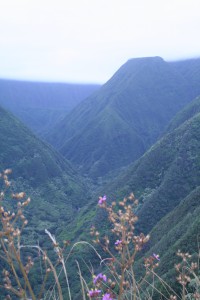
Waihee Valley from the ridge.
(6.9 mm) Waihe’e Ridge Trail
GPS Coordinates: 20.953104,-156.532334
This is a wonderful steep hike along a mountain ridge. Spectacular views of the Waihe’e Valley and coastline, plenty of birds, and you can get a good cardio workout going up the steep incline. I wrote a dedicated article about this hike here: Waihe’e Ridge Trail
(1m mauka 4.8 mm – see map) Swinging Bridges
GPS Coordinates: 20.94131,-156.524502
Don’t believe the other guidebooks that say you need to hire a tour guide because it is difficult to secure access to this valley. This is a less steep hike than Waihe’e Ridge, into the Waihe’e Valley. This is the valley that you see so spectacularly from the ridge hike above. It is a 1 mile hike on a wide defined path to the bridges, and an additional mile along a narrowing path to the end of the trail. Detailed article here.
Key Info:
Mile Marker Span: #32 (Honoapi’ilani Hwy aka Hwy 30) to #0 (Kahekili Hwy aka Hwy 340)
View West Maui’s North Shore Sights in a larger map
 MauiGuidebook.com
Steve Kassel says:
Last Tuesday, June 27 we had reservations for Mama’s Fish House in Paia. It’s a 40 minute drive from Lahaina. However, while returning from a trip a few hours earlier to the Sugar Cane Museum we saw black smoke near Leoda’s Kitchen & Pie Shop. While getting gas a few minutes later, a local gentleman told us the fire department would close the road. He was right. However, Google Maps showed the road was open around 6:30 and we left from Lahaina for Paia shortly thereafter. We had 2 hours to make it. 15 minutes later, a Maui Police Officer told us, “da road is closed” so TRUSTING Google Maps, we decided to head north on Hawai’i 30 and go past Kapalua around the backside of West Maui to 340 and eventually get to Paia in time for our 8:45 PM. reservation which was made 4 months earlier in an early celebration of our 30th wedding anniversary.
It started off fine although the road got quite narrow UNTIL we got to a one lane bridge with NO warning signs or lights. I was more than halfway across when another car approached from the opposite direction. Hmm. I had no way to back up safely and the approaching driver did have room so he backed up. Whew. That was the end of that. WRONG. Remember this is after sunset on a road I have never traversed in a CHRYSLER 300, which is WIDE.
Three more of these one-lane bridges in the next 10 minutes and numerous signs advising to HONK YOUR HORN to let approaching drivers know you were there. Thank G-d for small favors! We were probably an hour into this adventure when Hawai’i 30 ENDS and the road becomes more narrow with a myriad of hairpin turns and FALLING ROCKS signs that were absolutely true. Oh and up, up, up and down, down, down with virtually zero visibility because there is a cliff on your left and a mountain on your right. Then, TRAFFIC STOPS.
Off in the distance, we see HUNDREDS of car lights and an ambulance and a fire engine. A full-size Maui Fire Department engine. After 20 minutes or so, a godsend comes by our car. Some local Hawai’ians told us they would help get us through. It was if Madame Pele had dropped them down to help us. Eventually, the ambulance and fire engine squeezed through (how, I don’t know), followed by a stream of a couple hundred cars until the path was clear and we could proceed. The Native Hawaiians helped us as promised. Truly wonderful people like almost all of them on the islands of Hawai’i. We’re done right? Hell no. The next 15 miles were insane. Over and over squeezing to get by dozens and dozens of cars for the next hour. Up and up then down. Tiny bridges at absurd angles. Whoever engineered these bridges should be drawn and quartered!
Eventually we saw lights. Oh, I didn’t tell you? There was ONE street light in two hours plus of driving. This is EASILY rectified if anyone cared. Still another 20 minutes until we reached Kahului. Mama’s Fish House? WRONG. It was already 9:45, an hour past our reservation and of course, there was no cell service.
Fortunately we found a Thai restaurant that was still open i. Kahului and we ordered, they brought it to our car and we drove back to our hotel. BUT, it took another 70 minutes because 30 was still closed…then open…then closed.
We were very happy that when I called Mama’s the next morning they had openings Thursday, June 29. Wonderful restaurant. It’s expensive, but if it’s a special day or night, it’s worth it. If you go here regularly, your finances are not a factor. Oops. Another story. That morning, June 29 I developed double-vision. I literally drove to and from Mama’s with my right eye closed.
It got so bad that instead of flying to Hilo on Friday, we changed our flight plans and flew home to San Francisco Friday morning. Upon arriving home, we went to the Emergency Room at Kaiser South San Francisco where I received fantasticcare. I was admitted to the hospital where I spent 2 nights. Our worst fears were NOT realized. I did not have an aneurysm, a stroke or a tumor. I do have Cranial 3rd Nerve Palsy, likely caused by diabetes (even though my A1C is not very high). In most cases it resolves itself within 4 weeks to 3 months. If not, surgery is an option. At first my left eye was open fully and my right eye was looking to the far right. No jokes, please. Now, my right eye appears normal, but my left eyelid is mostly closed. It changes daily. Needless to say, I am NOT permitted to drive. If this had happened while on the backside of Maui, we might have died. Seriously. Do not drive this road at night. All but one of the Mauians I talked to said it was far too scary to drive there. We actually found a couple from southern California that drove it in the opposite direction because after the incredibly easy Road to Hana, the only way back from Kahului was to drive 340 to 30. Normally there are virtually no cars there at night. Maui PD SHOULD have closed it north of Kapalua and north of Kahului except to local drivers as I’m told is often done.
Tony says:
I did this drive today, kind of by accident, and it was unbelievable!!!! Early morning so very few vehicles…maybe 10 the entire drive . Unbelievable views and scenery ! I cannot believe people live there! Road was very scary in a couple spots and my anxiety kicked in but I just went slow and made it. Not sure what would happen if two cars met in the middle of the one lane parts…back up I guess. And some of the narrow, sharp turns where you can’t see anyone coming!!! One of the most beautiful things I’ve ever seen. Unfortunately we drive thru Lahaina to get there…not beautiful, but rather quite tragic. Today is oct 6 2023
Liz says:
Just thinking about all the lives lost on that day you are describing.
SMH says:
He wasn’t describing a day where people lost lives
Theresa says:
So, after reading all the comments, my travel companion would not be up for this drive. How far should we go along the Northwest coast, traveling east before we turn around? (before it gets bad)
Angie says:
Honestly, it gets twisty and narrow right away, coming or going. I was terrified the first time we did this drive but I absolutely loved it and have done it again multiple times. It is completely worth it! Much more fun than the Hana drive.
Eddie Wilson says:
I did the full West Maui loop on Tuesday, May 24th, 2022 on a rented 200 CC Moped. I started at 808 Mopeds in Kaanapali and made a full circle around West Maui!! It was absolutely one of the most adventurous and exhilarating thing I’ve ever done!!! It was absolutely gorgeous AND at times absolutely terrifying!!! I would not do it in a car! There were many times I had to back up as there was not enough room for a car and a moped. There was barely enough room for a car!!! But the Blowhole and Iao Valley were just amazing and everything else was beyond incredible. My advice….IF you do this….do it on a moped
Josephine B Rust says:
we drove this road in April of 2021 on the recommendation of my boyfriends boss because “it was much better than the road to Hana and with less people”. I was driving so I didn’t see the tow truck that was pulling the car off the edge of the cliff that was on the next turn above us but my boyfriend did. There were signs all along the road about honking which I finally figured out was to let people know when you were coming around a blind curve. We got to the top of where there was a bit of a turn out and was just past where the tow truck had pulled the car back from the edge and my boyfriend suggested going back but I thought no way, how it could the rest of the road be worse? I have to say that it was. When we got to the end of the road we were SO glad to see the golden arches of McDonalds that we hugged each other.
I wish I hadn’t been so terrified when driving it because there are some beautiful views and things to see but I’m afraid that I/we will never drive that road again. We did some research when we got back to our hotel and read an article that referred to it as “the death Highway” and one of the top most dangerous drives in the world. We did laugh when were in our hotel room during the rest of the trip when ever we heard some horns honking because we were sure they were someone that had just driven the road and were so happy to still be alive!!
Jennie Booker says:
Well, I sure wish I had read this and checked Google maps before driving this route to the airport. I had driven the road to Hana a few days before and did ok with the help of Dramamine. However, I was completely unprepared for this drive and quickly switched with my husband so I could drive, but it was too late. Twice, I stopped in the middle of the road to throw up out my door—and this even with Dramamine. It also didn’t help it was in the complete dark. At one point I told my husband and kids to just leave me and I would walk to the airport and catch a flight the next day—I was that miserable! Luckily, I made it out alive and didn’t miss my flight. Never again!
Steve Kassel says:
Google Maps is NO help whatsoever. I will be talking with them in the next few days.
William says:
I lived on Maui for nine years and this drive is a great escape from the congestion elsewhere on Maui. If I were staying in west Maui, I would take this route from the airport. No better way to immerse yourself in the spirit of the islands. Anyway, 99.99% of the cars don’t go over the edge.
Kathy says:
We made this drive years ago and got as far as Kaukini gallery and then turned around and went back the way we came. I was not driving. Is it really best to keep going? I think I’m confused on the way back to Mahaina
Zach says:
There is some great info here. Wish I would have read this before we made the drive about going clockwise, but then it was an amazing adventure anyways. We ended up driving counterclockwise after an early morning drive up to the summit of Haleakala. Decided to take the long scenic way back and definitely had to pass a number of cars on skinny cliff edges, but only had to back up once. I’m certainly on the more skilled end of the driving spectrum, but nothing was too difficult- just could be mentally taxing if you focus on where you don’t want to be instead of where you should be looking. We did it in a Jeep which helped at points where we had to really get off the road to help less, uh, talented drivers through. I’d definitely do it again, and take more time to check out the sites. We did get to stop at the blow hole which was fascinating. Worth the trip. Take it slow, and enjoy the scenery!
Al says:
In general, the leeward side is the drier side, and the windward side is the wetter side.
I lived in Hana for two years. The road to Hana is very safe, as long as you use common sense and yield to locals that know every turn of the road far better than any visitor possibly could. The road around West Maui is dangerous if you’re not a confident driver. Don’t even think about driving it if you aren’t. Always go from the Lahaina/Ka’anapali side towards Wailuku. It is the general flow of traffic, plus it puts you on the inside of the road in the event you meet anyone. Always keep your eye as far ahead as possible so that you can plan where to pull over or stop (at the widest point in the road) if you meet anyone. The sights are beautiful to see. Especially the hike down to the light house, the blow hole (as long as you don’t get close to it), and the beautiful village of Kahakuloa.
I will say that this road was not made to accommodate a ton of tourists. The road to Hana is already way overcrowded. At some parts of the day, this road is, too. Respect it and the people who must use it everyday.
Terry says:
We drove it a few years ago with my wife driving. Looked interesting on the map. MOST IMPORTANT….Drive the road clockwise from West to East. Unforgettable (but my wife may never forgive me as it was without doubt the most stressful drive of her life). Way more challenging than the road to Hana . We passed a local car on a cliff edge on a corner (he was on the outside) and I thought the poor man and his three dogs were going over, but he made it. Not for the faint of heart. Nice scenery and the village halfway on the drive sells great banana bread. If you do drive, keep reminding yourself that school buses drive the route.
Dave says:
I had to chuckle when I read the “cliff-edge driving you’ll never forget.” I drove this back in 2008, and while the views were spectacular I would never do it again. My wife and I still use it for comparing bad drives, as in “well at least it’s not as bad as that drive around West Maui!” It does make the Road to Hana look like a piece of cake.
Toni says:
How long should we plan out of our day to make this drive if we explored the sights listed in this article?
Mark says:
My suggestion is not to plan it, and go with the flow! Give yourself the better part of the day, plan nothing before and after, wake up when you wake up, take your good old time getting moving, and plan on this being where you spend your day. Really, I have found, this is the best way to do it 🙂
Mary D. says:
We just got home today from our two week stay in Maui We have been coming out since 1997. We bit the bullet and did the Kapaula to Kahilui route going around the west side of the island just the other day (in a Jeep). I was not driving. Seeing the two smashed up trucks on the side of the road that obviously once went over a long time ago was pretty daunting…but approaching that tiny village where suddenly the road becomes a dirt driveway with the kittens and chickens running back and forth across—not to mention the people too—that was a bit much for me. At that very point I told my husband it would be worse to turn around than to just keep going…so we did. It was worth it…but now I guess we will have to come back and actually “do” Hana as we haven’t done that yet either! (Our server told us yesterday that the road we were on is in many ways worse than the Road to Hana!) Great. We earned our bravery badges then! Aloha!
Roger says:
Dont worry, the roads on west maui is made safe enough for the school bus. Just dont hurry
Mary Cutrera says:
The weather men always talks about the leeward side and the windward side of Maui without indicating where that is.
Mark says:
Aloha Mary – Windward is the side of the island that faces into the tradewinds, leeward is the side of the island shielded from these pervasive winds by the mountain. Tradewinds come from the East-Northeast. The majority of Maui resorts are located on the Leeward side of the island, All of Wailea, Kihei, Lahaina and Kaanapali are in the Lee.
Dayle says:
The easiest way to remember is this: Lahaina is on the “Leeward” side. L = L.