Rating: 

In a nutshell: Hike into the clouds, with spectacular views.
Minuses: Fairly steep 2.5 miles, can be slippery back down.
Sound-bite: [Birds singing]
This is a nice hike with spectacular views. The photos here don’t do the views full justice. Every direction you look, you’re treated with a different view – lush rainforest valley, Makamakaole Falls in the distance, and many spectacular views of the ocean, isthmus and Haleakala side of Maui.
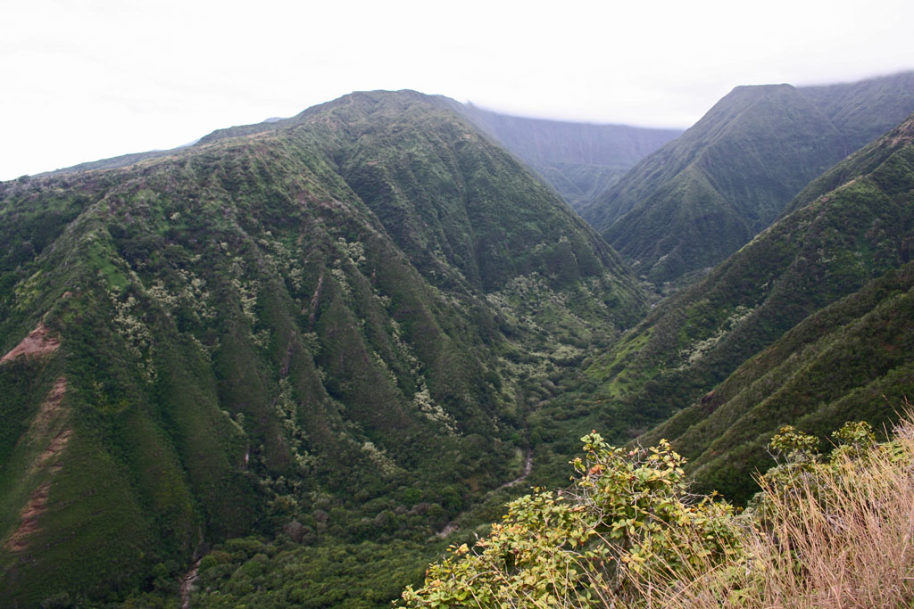
One of the many spectacular views into Waihee Valley
If you’re a birder you’ll be in heaven as you’ll encounter plenty of birds, several you’ll see nowhere else in the world.
More ferns than you can shake a stick at, along with Ohia (both yellow and red) and many other endemic flora species.
The trail is well maintained, with a couple of benches at choice overlooks along the way. There is even a picnic table at the pinnacle of the trail.
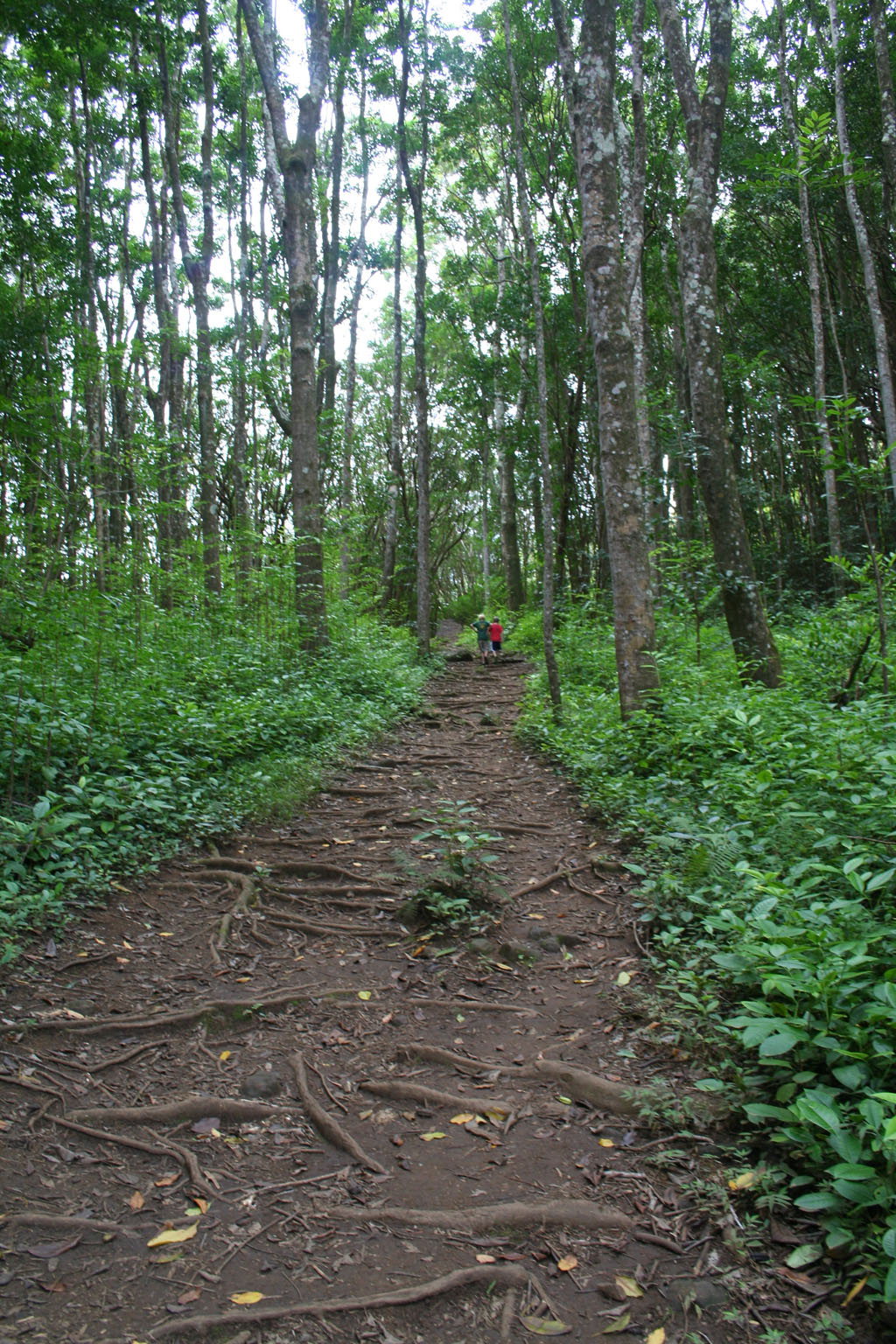
Waihee Ridge Trail starts out easy!
A few notes in getting here. The road to the parking lot is across the road from Mendes Ranch – if you aren’t paying attention you might miss it. At the start of the road there is a parking lot – don’t park here! Continue uphill on the road 9/10 mile until you come to another fairly large parking lot. Park here. When you walk to the trailhead you’ll first be confronted with a choice of two gates, take the gate and path that go uphill.
Key Info:
Mile Marker: #6.9 (Kahekili Hwy aka Hwy 340)
GPS Coordinates: 20.953104,-156.532334
Facilities: None.
Get directions
View Waihee Ridge Trail in a larger map
Manaslu circuit Trek says:
It also helps a lot with practical tips like starting early for better views, and being ready for steep and sometimes muddy sections.
AJS says:
Many thanks to this website for helping us plan an amazing trip to Maui. Happy to pass on the good vibes so everyone can make informed decisions and make the most of their time in paradise.
We made it to Waihee around 9am on a Wednesday. We drove north from Napili Kai, unknowingly taking us through one of the island’s toughest roads (but we honestly loved the drive!). The lot was nearly full around 9 but we found a spot.
This is a consistently up-grade hike, with a near consistent elevation gain the whole time. It is STUNNING! the views of the coast plus the majestic hands of the mountain were unforgettable. Even though there was cloud cover over the top of the mountains in the valley, there was something foreboding and just right about it. Truly, this was one of the best hikes I’ve ever done and I’ve done many! It’s not that hard, just bring water and shoes with good support. I wore Hoka Cliftons and was fine.
Langtang says:
Waihe’e Ridge sounds magical! Love the mix of lush rainforest, rare birds, and ocean views—definitely adding this to my Maui must-hikes.
Lukla flight says:
Stunning trail! The views and birds sound amazing, and your parking tips are super helpful. Thanks for sharing!
Team Himalaya says:
Lovely and enjoyable. quite slick from the mud. It was too foggy to see anything when I went early in the morning, but as I descended, the fog lifted, allowing me to see all the steep drops I had been blindly navigating!
Hello says:
What time did you go?
Babu kaji Sitaula says:
Amazing path! We hiked in the summer, so there was no mud, but at times it was slick. For short hikes like this, we wore Chaco sandals because we hike in those in Colorado; nonetheless, we advise wearing at least sports high tops or hiking shoes because we developed blisters.
Mr. Prakash Chandra Devkota says:
wonderful route There was no mud because we were trekking in the summer, but it was occasionally slick. We do, however, advise wearing at least tennis shoes/sneakers or hiking shoes because we got blisters.
Bill says:
Great views are the reward for this rigorous but enjoyable hike. Took about an hour and fifteen minutes for the two of us to get to the top, including stopping often for pictures, and about 45 minutes to get down. Two hardest sections were the first 1/4 mile on the concrete road and the switchbacks about 1.5 miles in. Very muddy and slippery in sections. I would definitely recommend hiking shoes, and tracking poles would be a real bonus, although we say many attempting it in sneakers. We got there at 7:30 and had plenty of parking spots, but the upper lot was full by 9:30.
Haley says:
Great views but very steep for the majority of the way. Even without any rain or mud had a few falls on the way down. The first lookout point would be the perfect time to turn around.
Get there early for good parking and maximum shade.
Hanky Panky says:
The gate automatically opens at 6:58-ish. Do yourself a favor and get there at 6:50-ish and all the sweet parking is yours. As stated before, at 9:00 or so it’s packed and your walking an extra mile each way from the lower parking area. Great little stroll and the views are incredible! Helicopters are all over paying big bux for the gobsmacking views you just have to work for a little bit. This site, mauiguidebook.com has the best info we’ve found. Enjoy!!
Nate says:
We got to the upper parking lot at 8AM today (a Thursday) and the lot was about half full. By the time we got back down to our car around 10:30 the upper lot was packed full and the lower lot was about 25% full. The hike was awesome. We stopped about 3/4 of the way up because it started to rain a little and we didn’t have any rain gear. It can get slick if things are wet, but the views were awesome. We loved it and would definitely recommend it.
Hannah says:
Got to the parking lot at about 7:30am, and the trail was pretty much empty! Beautiful views, even on a cloudy day, though at the top there wasn’t much to see, as we were in the clouds. It wasn’t muddy at all and didn’t rain until we were descending. The trail itself was pretty steep, and I would say is an intermediate hike but definitely a good workout. When we got back to the parking lot around 9:30am it was PACKED and there were people waiting in line for our parking spot. The other lot that this site says to drive past is essentially the overflow parking, but it adds a half mile or more of uphill hiking to the already steep climb. Overall, if you are able to go before the crowds, it’s a great way to start your day! My family also stopped for breakfast at Tasty Crust, about 10 minutes away from the trailhead.
Kelly says:
Lots of people saying get there before 7 AM. We arrived at 3 PM and had no problem finding parking. The views are spectacular all along the trail. I’m 53 and in average shape and still made it to the top. Not an easy hike but nothing technical. No mud on the day we were there. Enjoy!
George says:
Quite a tough hike, especially when he last 1/3 of the way. We’d have been satisfied not completing the trek, but we’d be curious about the finish! Be ready for heavy breathing!
Mike says:
This looks like a great hike! My fiance and I are heading to Maui in June and love hiking. I have a drone that I would love to fly but want to make sure I’m following local laws. It looks like this hike isn’t in a national or state park where drones are typically forbidden. Does anyone know if drones are allowed along the ridgeline?
Ken Caldwell says:
You likely don’t want to hear this, but take it in with your eyes. Don’t worry about your friends experiencing the same thing as you. #dronesnotsomuch
Hannah says:
I am wondering this too… I think it would be permitted but if you find out anything else please let me know!
Brenda says:
Please, no drones for the enjoyment of other people and the peacefulness of the birds as well. Sacred space ??
Colby says:
My wife and I did the hike the beginning is An extremely steep concrete ramp, for I would guess the first 1/4 mile. It’s a 2.5mile walk uphill almost the whole way and quite steep at times. We are not experienced hikers so it took us 2 1/2 hours to walk up and an hour to walk down. I personally wouldn’t do the hike again I would rather hike to a waterfall if I am going to hike such an extreme climb. The mud wasn’t an issue because we started around noon. Halfway up is a scenic platform and imho the view doesn’t improve significantly at the top and unless you want to say you made it the whole way. Don’t believe the people that say it’s not that bad unless you are into hiking steep mountains, it’s 5 miles roundtrip with a 2000+ elevation climb.
Nicole Dewell says:
Great trail! We hiked in summer so no mud but a little slippery at times. We wore Chaco sandals as we hike in those in Colorado for short hikes like this but recommend at least tennis shoes/sneakers or hiking shoes as we got blisters. Beautiful views -just amazing. I recommend getting there as close to 7 a.m. as possible as the parking lot fills up.
Kevin says:
Is there any way to start this hike before sunrise, or does the gate keep you from starting earlier than 7:00.
Rohit Rai says:
Hello !
I want to do this hike however I do not have a car to reach the trail head. Is there any public transportation that goes close to the trail head?
Thank you so much.
Mark says:
I’m sorry, this area is remote and there is no public transportation here. In fact our bus system is extremely limited and is a very poor choice for visitors. I strongly suggest renting a car. Have a wonderful time!
Ismail Sencer says:
Is this trail open?
Mark says:
Yes it is!
Glenda says:
Under key info / facilities, it says “none”. But there are in fact two outhouses in the main parking lot. Just FYI.
Toni says:
My family hiked this yesterday afternoon. The mud wasn’t bad. —Maybe because of the time of day, but we didn’t experience any slipping. It took us about 1hr and 20 minutes to get to the top, and about 30 minutes to descend. There’s a lot of uphill, but other than being a great cardio workout, it’s not too challenging. I never felt like I was in danger, nor did I have to use my hands for climbing…it’s not that steep. The views from the top are definitely worth the work to get there!
Yong Rhee says:
This was not easy hike because mud and slippery, appeared few injuries hikers. Recommended must have a hiker stick and good hike shoes.
Basil says:
Beautiful and fun. Very slippery due to mud. When I went early in the morning, it was too foggy to see anything, but on the descent it cleared and I saw all the steep drops I had been unknowingly navigating!
Mark says:
Eight hikers in our group. Four of them did not make it 1/4 mile up due to mud. Others made it to top. If we do it again we’ll only go to the first viewing area. It is most beautiful anyway. Not much to see at top except clouds. Bring extra pair of old shoes for hiking.
Steve says:
The parking lot, gate, and hike are open 7 AM to 7 PM.
Jeanne says:
Limited parking so make sure you go early. After an hour of driving I was super-excited for this trail, only to be one of many cars waiting for a spot at 10:00am. Was yelled at by a resident for being “part of the problem.” Ended up turning around to avoid the bad energy.
Denise says:
I am not an experienced hiker and found it difficult but I am so glad I persisted. It took me 1hr 40 to go up and 25 min to descend. Cloudy at the top but still happy I did it. Wear good traction shoes. Google map said the trail was closed but we are happy it was not.
Matt says:
This was a fairly difficult hike, primarily due to the mud. We hiked with our children, all experienced hikers, and it took about 2:45 round trip. The mud slows things down significantly. Views are great.