Rating: 
In a nutshell: Blowhole and scenic rugged coastline hike.
Minuses: If you’re not sure-footed parts of the trail can be challenging.
Sound-bite: [hssssst….BLAST!]
Blowhole safety
In Maui it has been customary to allow the careless free control over their destiny. But if you come from a place where they would put a barrier around dangers, then they would most definitely have one around the Nakalele Blowhole.
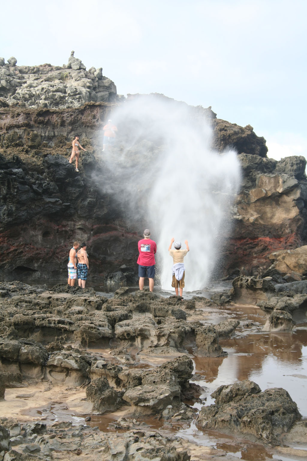
You’ll undoubtedly see visitors walk up to the blowhole and look in, or position loved ones very close while they try and snap that perfect picture. If you get too close to this you can be sucked in, and that’s the last anyone will ever see of you. It has happened here.
What also happens here are larger unexpected waves sweeping across the lava and pulling visitors into the ocean. Observe the waves for some time before walking down. Look for signs of water sweeping across the area and stay back from areas that are experiencing wave action.
If you’re looking at the map below, first thing you’ll notice are two parking areas with trails to the blowhole. If you’re less mobile or traveling with little ones, the closer area at the 38.5mm would probably be your best choice. This area is also overlooking the blowhole so those who prefer can view it from a distance without having to hike.
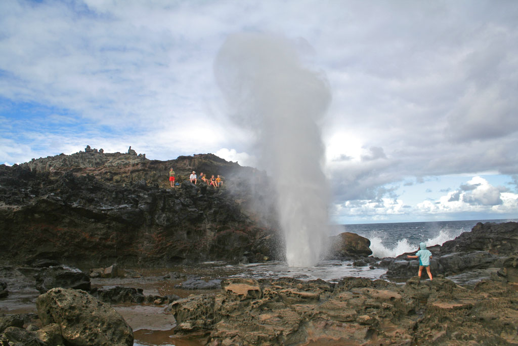
A tall blast at high tide.
I’m going to describe Nakalele Point as it unfolds on a 1.25 mile hike (round-trip) from the other parking area (38mm.) As long as you’re able to hike though somewhat rough terrain, taking this route is actually better for seeing all the places listed below.
What’s a blowhole?
A blowhole is hole in the ground that connects to an underground, partially submerged ocean cave. The cave and opening are shaped in such a way that when the ocean rises or waves crash into it, a jet of water and air is violently forced out through the hole.
Read in Tidbits
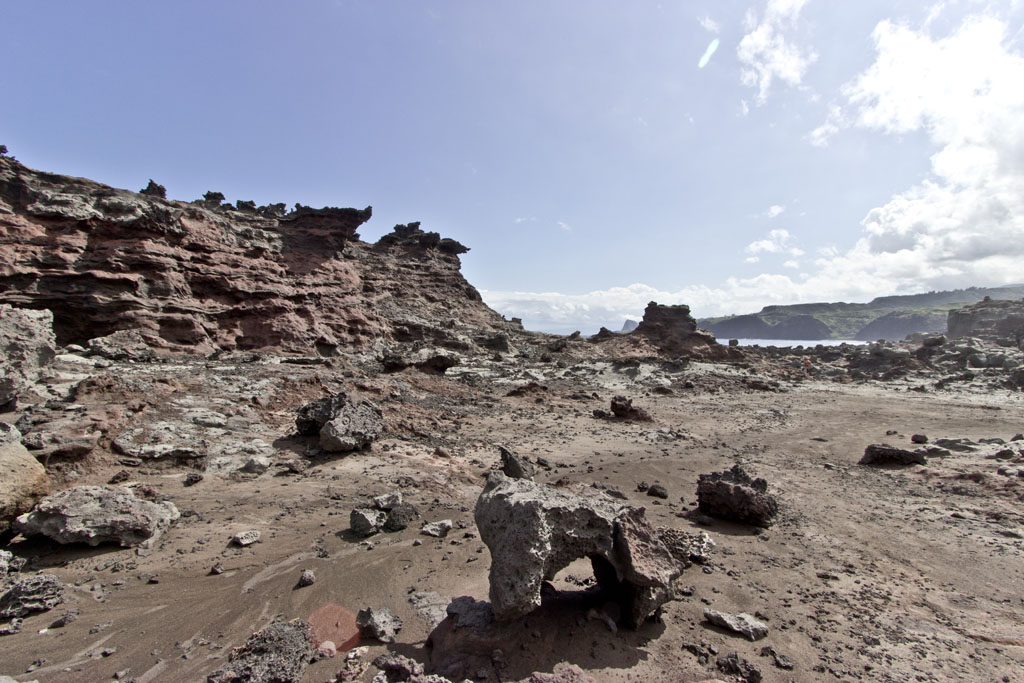
“Acid War Zone” Rock formations
Dirt Bike/ATV Trails
Between the 38mm parking area and the light beacon is a maze of dirt bike and ATV trails. These trails were laid without a destination in mind, so just pick any trail that suits your mood and meander out toward the light beacon.
“Acid War Zone” Rock formations
Light Beacon & Tidepools
GPS Coordinates: 21.028951,-156.590506
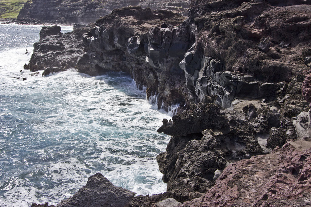
Light-what? Think of it as a lighthouse, only smaller and stripped of all charm and artistic value. (I can just see that slogan now on the travel brochures!) But what this beacon lacks in ambiance it makes up for in views. Stand on the concrete slab adjacent and you’ll also get a good view of the tidepools below. What you’ll also see is an old rickety ladder, precariously positioned on the cliff-edge, beckoning with the promise to deliver adventure. (At least that’s the way it looks to me…) As tempting as it may look, going down to this tidepool area (let alone on an old precariously positioned rickety ladder of questionable functionality), well…lets just say it is certainly not advisable.
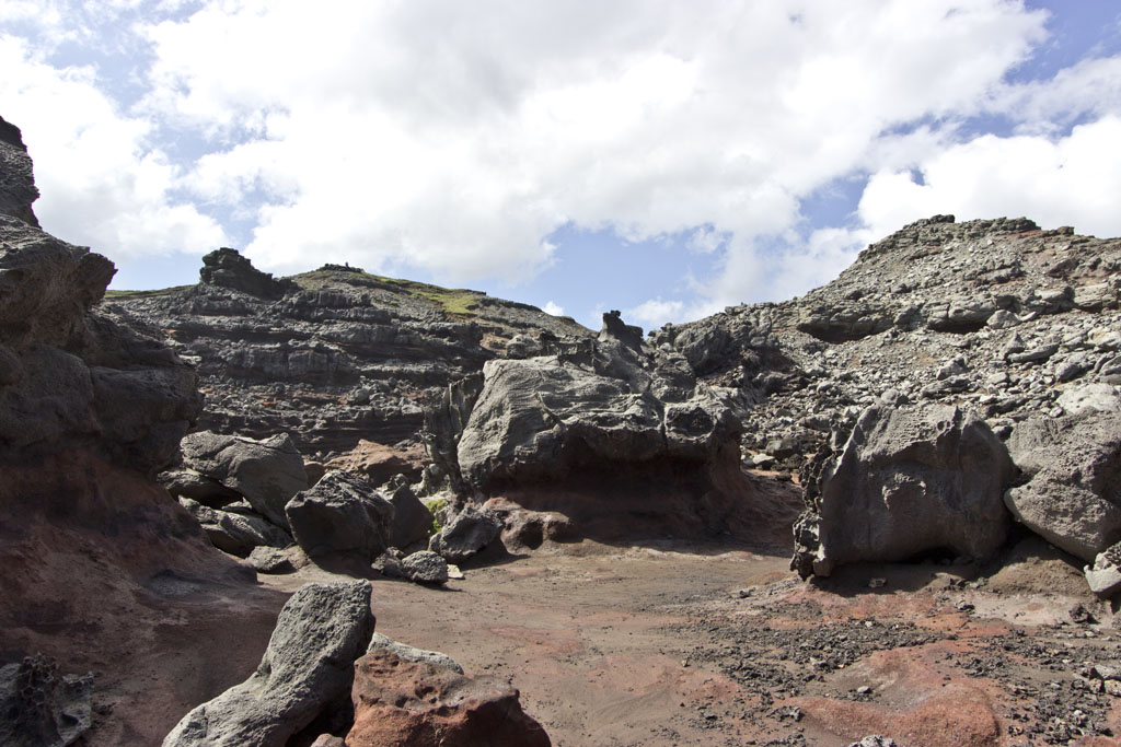
One of many cliffside vistas hiking through the “Acid War Zone”
As you continue on, the trail goes downhill for a short bit, and this is the likely going to be the strongest test of your sure-footedness. If you’re with a group (and especially kids who can’t resist the temptation to release kenetic energy) being at the back of the line here is key strategy for remaining upright throughout your descent. Once at the bottom you’ll begin to get some previews of the “Acid War Zone” and some more dramatic views of ocean and coast, along with another very nice tidepool, this one fed in part by a small blowhole of its own. (Don’t confuse this with the main attraction!)
“Acid War Zone” Rock formations
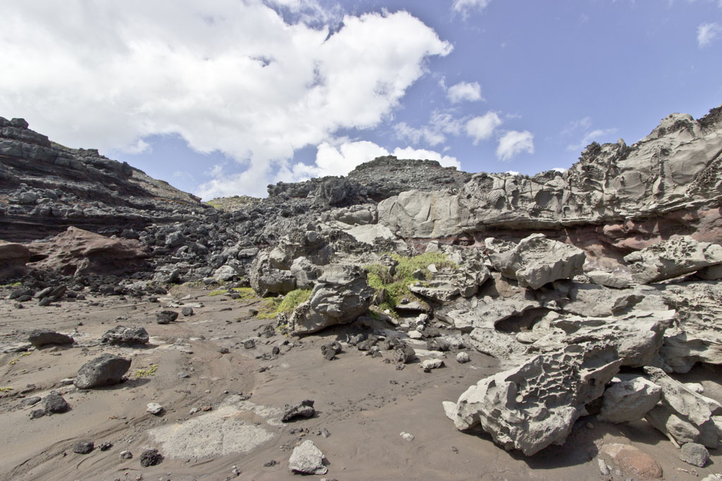
Acid War Zone
GPS Coordinates: 21.027820,-156.589235
The fantastic name of “Acid War Zone” has been coined for an area between the light beacon and the Nakalele Blowhole. It is a sight that is definitely impressive and worth checking out when you find yourself out here for the blowhole. As the name aptly describes, it is a barren landscape where boulders have been severely pock-marked, sculpted, perched precariously, and otherwise dramatically eroded by countless years of salt water spray.
A woman conjures the spirit of the blowhole
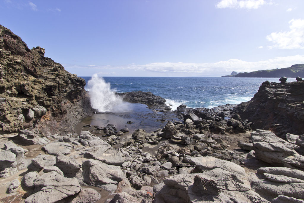
(38.5 mm) Nakalele Blowhole
GPS Coordinates: 21.027013,-156.588559
The prime attraction of the Nakalele Point is, of course, the blowhole. A blowhole’s effect is much like that of a geyser: a hole in the ground with a jet of water shooting periodically into the air. (See sidebar for technical description & safety.) This blowhole is large enough to accommodate a manhole cover and is powerful enough to easily blast it high in the air – especially during high surf and tides. (tide forecast) Some jets can approach 50+ feet and if you’re close enough you can feel the ground tremble beneath your feet as water is blasted skywards. Now, I know no one likes safety lectures – but I have never once been here without seeing several people do incredibly stupid things. I figure it is because they don’t know the safety info above and/or figure some governmental authority is looking out for their safety (just for the record, they’re not.)
A secondary small blowhole and pool
Key Info:
Mile Marker: #38-38.5 (Kahekili Hwy aka Hwy 340)
GPS Coordinates: (light beacon): 21.028951,-156.590506
Facilities: None.
Get directions
View West Maui’s North Shore Sights in a larger map
Frank says:
Parking is now paid at the two main blowhole parking areas. Cell reception is good. The parking fee is good for a zone that covers the blowhole and DT Fleming State park beach.
Kristen says:
Hwy up to blow hole is a 1 lane road..
Go slow and keep lookout ahead of time for cars coming toward you..
Kristen says:
Hwy 340 is the 1 lane road!
Susan Dezirey says:
CAUTION:
Please keep to the dry rock areas. too many tourists (and locals) try to get pics of the inside, but the waves can sneak up and will pull you in! people are even knocked down to the ground near the hole, just from the waves & spray.
Amy says:
My plan is to pass where the trail starts and park where the trail ends. This is to be closer to the big blowhole. No parking lots, so park on the side of road. Hike for 15 mins to the big blowhole. Be careful and watch for waves that can sweep people out to sea and drown. Skip the second blowhole and light beacon.
Does that sound like an accurate plan? Have I understood correctly?
Emily says:
How long should we leave in our itinerary for seeing the blowhole? Trying to plan as best we can…thanks!
Stacy says:
Once you arrive I would say 1 hour or so is sufficient to explore the area. We parked on the side of the road and used the dirt trails. We passed others leaving and after a short walk, we were all alone which was nice. If you prefer an easier walk and nicer parking, keep driving up the hill and you’ll see many cars at the top in a parking area. You can then hike down and explore if you like.
Tessa Andrews-Biele says:
Where can you rent the ATV’s for the nearby trails?
Lizbeth Bravo says:
hey does anyone know if you need to pay ahead for parking?
Mark says:
This is a rugged natural spot that is not a park. There is no parking lot and you do not need to pay.
Alex says:
Nope, parking is free. google the location. You just park on the site of the road. Enjoy!
Mike says:
The comments above are correct. Very few warning signs, and I did not see any official ones. I saw one hand-written one that said something like “This is not a water park, Stay away from the blowhole. It can kill you.” My wife drove me nuts all over the island when she would lean way out over the edges of cliffs to get the “perfect photo”. At the blowhole a local told me “She shouldn’t be doing that; people get blown off the cliffs.” That photo isn’t worth losing one’s life. As someone alluded to above, it isn’t the governments job to keep you safe here; it’s yours.
David Jackson says:
How long does 340 take to drive from ka’anapali to Kahului? With taking the hike to blow hole.
Peter Lee says:
It’s a short drive, distance-wise, from Ka’anapali to the Nakalele Blowhole, but travel on the winding roads is slow. The hike to the Blowhole is also short, maybe 15 minutes, but slow with the rocky uneven terrain and winds.
Neal C Cosby says:
My wife and I experienced the blowhole at Nakalele in Aug 2019. Worth the drive, worth the hike down. Worth it! Will visit next time in Lahaina, Maui.
– Neal
Timo Mariels says:
Does anyone know if the tide pools mentioned were used as a ‘Queens bath’ or are part of a heiau as it appeared to have manmade rock formations within the pools and also was surrounded by small white plastic hollow poles that have been cemented into place as if to protect the area? It seemed like a sacred place, please shed any light you can! Mahalo!
kitana says:
“queens bath” is located on the island of Kauai. the poles are actually for fishing rods
Rob Vovk says:
Went to see the Blow hole and it was amazing, definitely need to be careful when getting down on the lower lava. Very slippery when wet. Probably more dangerous was the Hwy 340 that is one lane most of the way. It was fun but took a long time. Be careful if you go on past the blow hole, way worse than the Road to Hana!
John Huston says:
Seen the blowhole in August 2017 was amazing, highly recommend to see when in Maui,great hike over rough terrain be careful.
Mary says:
An old school friend of mine was laying on the rocks and got swept up by a wave last week. He drown. Be very careful, even if you are on land, on the rocks, you can be swept into the ocean.
Walker says:
We live on Maui .Please use caution .Blowhole is great . Avoid any wet areas . Look carefully before getting close . Many are unaware of the dangers here .Keep kids very close.
Article is correct people get swept into rocks by waves all around coast of Maui even locals .Cliffs are great stay low because of wind and please use extreme caution all around our beautiful island . On the beaches please do not turn back on waves when in water . There are few warning signs here .Have fun and good luck
Pat says:
Why “do not turn back on waves when in water”?
Rodney says:
so u can see the big sneaker wave coming.
Karlene Cameron says:
Great article! Thanks for the details! I’m on vacation here in Lahaina this week and decided to go see the Blowhole! Certainly glad I went, and glad for the cautionary advice.
One thing, at about mile 38 (near the lesser blowhole) there was a fairly large circle of rocks. Women were walking the outer circles and then meditating. Can you shed some light on what that rock circle is all about or the significance?
Mark says:
Aloha Karlene – it is a simple small labyrinth that new-age folks who are into labyrinths walk and do whatever labyrinth walkers do when walking a labyrinth (say that 5x fast!) I don’t know the origin of it, or much more about it – maybe another reader does?
Amber says:
Went on this hike this morning. It was fabulous! Be sure to bring a camera. I had a ride pick me up at the 2nd parking lot, so it was one way. It took about 2 hours, because I stopped often to shoot photos. Only saw one other person until I arrived at the blowhole.